Thursday, January 24, 2019

My River

In the summer of 2005, I worked at the St Croix National Scenic Riverway in Wisconsin. At our training session we were asked a very interesting question: If we had to identify with one river, one that we felt connected to in our lives or that was our favorite, which river would it be?

What river do I identify with? As we went around the room answering, I thought about it. Up to that point in my life, I hadn't spent a large amount of time on any particular river. I had never really thought about it. I didn't really identify with any particular body of water. But as I kept thinking about it, I realized how wrong I was. There was one river that was always there and it was such an undercurrent part of my entire life that I took it for granted without really considering it. But my river was always there.

My river is the Mississippi River.

The mighty Mississippi during record flooding in 2008, in Baton Rouge

Some of my earliest memories are of the Mississippi river levees in St Charles Parish in Louisiana, where I spent half my childhood. And of playing on the levee at the horse barn in Orleans Parish. The river was right there, just a very quick bike ride away for the first 9 years of my life. From the street in our neighborhood you could see ships towering over the levees when the river was high. And when the river was low, you could go over the levee to the river side and play in the "batture" - which is the French word for "shoal". All of that brings us around that the batture is "an area of shallow water, especially as a navigational hazard" (source) and that basically sums it up. It's an area that's dry during low water, often has flood tolerant trees and shrubs growing there, and would definitely be a navigational hazard during higher water. In the photo above the batture is from where I was standing to about the trees. The main channel of the river is beyond that.

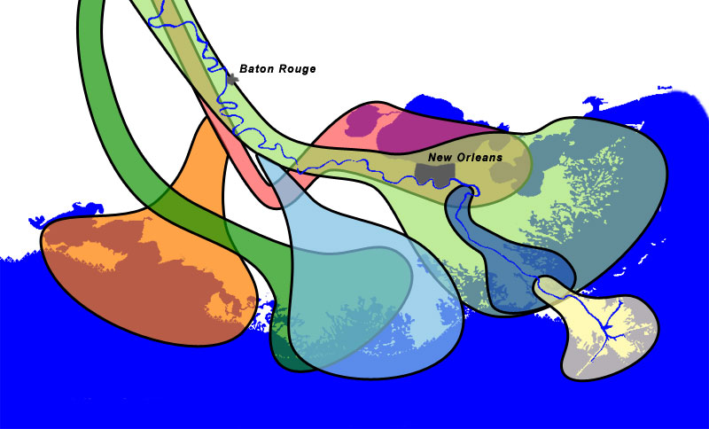
When I was about 9, we moved further away. Not that far, not really, but away from the current banks of the Mississippi. And while the Mississippi wasn't a daily sight, let's be honest, south Louisiana would not be the place it is without the Mississippi. Lake Pontchartrain is an old Mississippi River delta, and the north shore of Lake Pontchartrain was formed by the Mississippi as well. So even though I didn't see the river daily again until college, I lived on the northshore, which was literally land shaped by the river. So really, I was still connected to it even though I wasn't aware of it daily. At the time I didn't know that Lake Pontchartrain is an old abandoned delta of the Mississippi, but it makes the time driving across it on the Causeway that much more poignant to me.

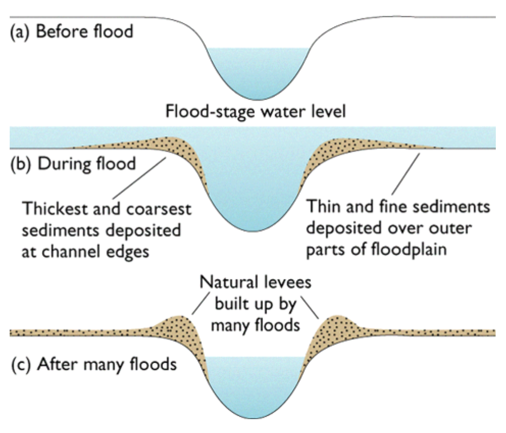
And then I moved to Baton Rouge when I was 18. I lived not even 2 miles from the river most of the time I have lived here (I now live 5.8 miles away if you're wondering). I learned in college that Highland Road is called that because it's on the first high land from the river. In fact, this road is placed conveniently on the natural levee that the Mississippi created on it's own before we built man-made levees. Natural levees are formed when a river overflows it's normal channel and spreads out, slows down, and drops it's sediment, creating ridges - natural levees. And Highland Road is on that natural levee, which I had never thought about before but for anyone familiar with that area, everything west of that road up to the river is much lower and floods so easily, including the LSU campus and nearly every apartment I had in Baton Rouge. 

The summer of 2005 when I went to work in Wisconsin, I didn't really think about it at the time but I basically went straight north along the Mississippi to get there. The Namekagon River, where I spent much of my time, is a tributary of the St Croix River. Which is a tributary of the Mississippi River. It all comes full flow. Not full circle though, because rivers don't work like that. It's really remarkable to me how things can be so interconnected and our lives be so influenced by factors that we sometimes aren't even aware of it.  

Just the other day, I hadn't seen the river in a few days and kind of just wanted to say hello. It was wrapped in a thin haze of fog, and looking awfully high for January, but nonetheless it's still my river. 


So all my life I have either lived practically within sight of the river or on land the river created a long time ago. I'm amazed at how my river has influenced me so much - my memories, my life, my state, my passions, my fears, my career, and the land I've always lived on. What is your river and how has it influenced you?

Wednesday, January 9, 2019

Taming the Mississippi, Part 2: Riverine Processes

Part 1: Wetlands Perceptions
------------------------------------------------------------------------------------

The whole point of this series is to discuss all the ways the Mississippi and coastal Louisiana has been impacted by everything in the past to create the current situation. You really can't talk about the Mississippi River and ignore the wetlands, and vice versa. One created the other, and they are interconnected, interdependent, and yet so very very different.

But for this Part 2, I want to focus on riverine processes. 

Rivers have a few basic parts: the headwaters, the channel, and the mouth. 

Rivers are born from their headwaters, and continue their journey from there. The mighty Mississippi springs to life from a lazy little outflow of Lake Itasca in Minnesota, and slowly winds through some beautiful wetlands as it begins its long meandering journey to the Gulf of Mexico. Some rivers start from glacial melt, underground springs, or as a branch from other rivers (these are called distributaries). 

The mouth of the river is where deltas often form. Not every river creates a delta, but the Mississippi does/did, and an expansive one at that. We often call it the birdsfoot delta, in that the delta is a bit far away from the main portion of the coast and looks like a leg and bird foot. The Atchafalaya River (a significant distributary of the Mississippi) has a beautiful delta that is healthy and growing and wonderful.

The flow of the river carves out the channel, and the main body of water often stays in that channel. However, during flood stages, the river may swell up and overtop its natural banks and water will spread out along the floodplain. Hence why it's called a floodplain - it's literally the flat(ish) areas where flood waters spread out. During flood stage, waters spread out and slow down, and drop sediment. Coarser sediments that were suspended in the water column drop out first because they are heavier. So sands drop out first, and clays last. So then you end up with a natural levee along the river bank.


Since we're talking about the Mississippi, here's an example of that:

There is no "original" channel of the Mississippi River. Not really. It has meandered all over the place for most of its length. But, in Baton Rouge, it's moved east and west of its current location. In one of those more easterly renditions, it created a natural levee that is still visible today. And most people probably have no idea. Highland Road, which runs through the LSU campus, is a natural ridge. It is an old natural levee of the Mississippi River. If you live around here, next time you drive across Highland Road from east to west, and notice how the land drops off on the western side as you head towards the river. These days, the river is contained in levees a mile or more away from there,  so no longer uses that natural feature.


Within the water column in the river channel, rivers can carry many different things - physical debris, sediment, nutrients, flood water, pollutants, and fresh water or salt water. These can all have different effects at different parts of the system.

So rivers carry sediment in some capacity, and in that vein they can cause erosion and deposition along the channel. That's why river channels move over time, or sandbars shift back and forth, and why shallow rivers used for navigation need to be dredged. The sediment is ever moving.

I literally cannot have said it more clearly myself, so here is how deltaic wetlands are formed:

"Deltaic formation begins as sediment laden river water reaches the ocean and slows down causing much of the sediment to drop out of suspension. Over time this accumulation of sediment leads to the formation of bars and shoals that further divert the water, causing increased deposition. Flooding causes increased sediment loss, leading to the formation bars and shoals extending above sea level. This newly-formed land is colonized with vegetation, which leads to further deposition and speeds up the land-growing process. Floating mats of vegetation form causing the water flow to slow and drainage becomes sluggish. The large amounts of vegetation and low flow cause anaerobic conditions to form." [source: Wetland Formation]

Over time, these wetlands are self fulfilling. Wetlands capture sediment, and in turn build more wetlands. It's a beautiful system. This process is how southeastern Louisiana's wetlands were formed. As the Mississippi River swung back and forth over thousands of years (also known as avulsion), this process repeated over and over across many former deltas. What's left today is a vast system of coastal wetlands [which has it's own set of problems, to be discussed in a future part].


The river has been pretty settled in the current channel for a few thousand years now, and would love to switch course (if rivers had emotions). However, we have pretty effectively captured the Mississippi and forced it to stay on its course to our own liking. I'll discuss this more in depth in Part 4.

Stay tuned for Part 3, where I discuss all the values (economic, recreational, societal, environmental, and otherwise) of these coastal wetlands that were created by the Mighty Mississippi!

Note: 
For the purposes of this series, the lower Mississippi and how it has formed the coastal wetlands of Louisiana are the main focus. The channel has shifted over time above Baton Rouge and plenty between there and Cape Girardeau (see the Fisk maps from 1944). I also acknowledge that different sections of the river have different challenges and benefits. 


Additional Information and Sources: 
River National Geographic, accessed 1/1/2019
Should I trust that levee? Missouri S&T University, accessed 1/9/2019
Harold Fisk 1944 Maps Radial Cartography, accessed 1/9/2019
Wetland Formation accessed 1/9/2019
Mississippi Delta Lobes Wikimedia, accessed 1/9/2019
Mississippi River Delta Wikipedia, accessed 1/9/2019
How the Delta formed Restore, accessed 1/9/2019

Tuesday, January 1, 2019

Shopping Ban: Month 3 Update

It has now been 3 months since I started the shopping ban on 1 October 2018.
Parameters of my shopping ban
Month 1 Update
Month 2 Update

December was a weird month. I was overseas for ~2 weeks, in the field for another week, and then it was Christmas week, and also the federal government shutdown started. So quite a lot happened actually. However despite all that I did a really good job with my shopping ban and stayed within the parameters!

Things I purchased in December:
- Basic necessity toiletries - lotion, deodorant, contact solution
- 3 magnets while in London - allowed as travel souvenirs
- 1 book while in London - books when abroad are also allowed, as I like to buy a book from the places I travel. I bought Milkman, which one the 2018 Man Booker prize and it wasn't available at my local library. Also books are far cheaper in the UK than in the US and it was only £9.
- Household items - cleaning spray, toilet paper 
- Gifts for my parents and friends (gifts are also allowed)

So I did good!

My mom's birthday was also in December and I struggled with what to give her as a gift. So I ended up buying her 3 used books, all with thought behind them. I bought her 2 books that I really enjoy and think she would, and 1 that is a genre she likes but a Norwegian author (instead of an American author). So a gift, but also not buying new items since that's not necessary, and also they were bought at my local bookstore so bonus points for shopping locally.

In previous years I had made desktop calendars for family/friends as a gift. It's a relatively easy gift, and I'd use photos I'd taken during the year, which my family enjoyed. But this year it felt wasteful. It felt like burdening someone with something they will have to contend with in a year. Or feel the need to hang onto since it's semi-personal. So instead I opted to not give that gift anymore. I think a few people might have been disappointed but c'est la vie.

My temptations the last month have been items for a cause. I haven't given in but I've definitely been tempted. For example, I love what Nurdle in the Rough is doing! Her jewelry is beautiful, it's made from ocean plastics she collects and repurposes, and the metals are recycled. And I definitely want something by her and to support her on her mission. There are other shops and artists I love but that's one of my favorites.

Perhaps after the 6 months I can modify my rules to include supporting causes. That's something to think about during the rest of the first stage, which concludes in March.

Of the 5 things on my approved shopping list, I have only purchased 1 of them. Or well, from 1 category. I've purchased all but 1 thing I need for the NOLS course but have yet to purchase anything else on my list. Clearly none of these were items I have really needed!

I've also gone through my clothing another time and removed a few more things that I haven't worn since the first major purge. I think this will be a continuous cycle honestly until I'm wearing everything I own regularly. I can only wear and enjoy so much clothing so I'm still paring it all down.

On to 2019! I think this year will be a year of knowledge, and I'm continuing to learn a lot about myself, my habits, and my place in the world through this shopping ban.