Showing posts with label op-ed. Show all posts

Tuesday, September 24, 2019

The Bottle Showdown

There's been a lot of debate lately about plastic bottles, and plastic waste in general. AS THERE SHOULD BE. Because we are in a climate pickle and everything is connected. So let me lay it out for you as there are a lot of factors involved. 

Creating plastic bottles requires petroleum materials to make chemical compounds to create plastic, and then this is turned into plastic bottles. The everyday plastic bottle IS mostly recyclable (a lot of places) but it isn't actually recycled as much as it could be. And it can't be recycled over and over again forever. So there's that. 
Pros - cheaper, durable
Cons - only mostly recyclable, reliant on oil 

Creating aluminum cans/bottles requires mining bauxite, which is horribly destructive. But the everyday aluminum can IS totally and completely recyclable worldwide. And is recyclable time and time again endlessly. But it is a little more expensive than plastic for the company selling a product (water/soda/beer/whatever) in a container, but endlessly recyclable. 
Pros - durable, endlessly recyclable f-o-r-e-v-e-r and valuable enough that people WILL recycle
Cons - bauxite mining 

I'm going to ignore glass bottles because I don't feel like everyone using glass will solve our problems when it's bulkier and heavier and not everywhere recycles glass anymore, though it is also endlessly recyclable. 

So things that come in plastic bottles are mainly beverages - water, carbonated water, sodas, juices, on and on. Things that come in aluminum cans are also mostly beverages - water, carbonated water, sodas. Things that come in aluminum bottles are mostly beer. 

I feel like the beer industry is onto something here. 

I used to think the aluminum bottles were dumb, when I could just buy a can of beer. But the ability to reseal the container is helpful. But this doesn't just apply to beer. 

So my main question is - 

Why are we using plastic bottles AT ALL when we could use aluminum cans and aluminum bottles in lieu, which are endlessly recyclable??

I suspect the answer is profit margins because aluminum is slightly more expensive, and probably also stubbornness, and maybe with a dash of consumer appeal. 

But if companies like Coca-Cola and Pepsi stopped selling single serving plastic bottles and started using aluminum bottles instead, I would TOTALLY jump on that train. And I don't even drink that much soda. Before you jump all over me and say "but Rachel they do make aluminum bottles" let me tell yes I know. Coca-Cola does make aluminum bottles of the 8.5oz variety. But it's more of a novelty item marketing as "vintage" than a mainstream product aimed at solving a pollution crisis. 

I feel like much ado is made of bottled water, fairly enough, but the conversation often ignores bottled sodas. There's literally millions of bottles of soda sold everyday, And billions of plastic water bottles are sold every year. So much ado SHOULD be made of bottled water. Most people drinking bottled water have access to clean and safe tap water and that's unforgivable. 

But we ignore how many people also drink soft drinks on the regular that choose plastic bottles because they're resealable (especially if it takes them 3 days to drink a 20oz soda like me) over aluminum cans. What we need is CHANGE. 

CHANGE in consumer habits to drink less sugary sodas (for our own health). 
CHANGE in production to use less/no plastic for packaging needlessly (for the earth's health). 
CHANGE in attitudes towards everyone starting to do the right thing because it's the right thing to do. 

Virgin aluminum is costlier than plastic, and bauxite mining is horribly destructive as discussed earlier. But using recycled aluminum costs only 5% of new aluminum, and that loop can go on forever. And a lot of places already have high aluminum recycling costs. It's valuable enough that people can and will and do recycle it. So we can use the same aluminum over and over again and again forever. If we do that, maybe we won't need to mine as much or any bauxite anymore if all aluminum is recycled. And not using plastic means no reliance on petroleum, and no drilling or fracking or anything of that nature. Seems like an all around win to me. 

Resources
Aluminum bottle Wikipedia

Sunday, September 1, 2019

Review: Cleancult

I was running out of dish soap and counter cleaner, and loathe to buy things that come in plastic bottles. In my online searching I found Cleancult! Their products come in recyclable cardboard, and sounded pretty awesome so I placed an order to give it a try. I've now tried all the products so here's my reviews of them:

Counter cleaner - it smells great, seems to mostly clean the counters. Doesn't do well with anything greasy, though. Probably not actually disinfecting but for general counter cleanliness it seems fine. And it smells good too.

Lemongrass soap bar - I like the scent, it foams up nice and everything, but probably I'll just stick with my normal bar of soap after this. No fault of theirs, I just like my regular bar soap better.

Dish soap - I actually haven't used this one yet, but I have it to use. I didn't run out of soap as fast as I thought I would.

Dishwasher tablets - These come in a paper bag, and seem to wash the dishes totally fine. I was previously using a powder in my dishwasher and maybe I'll continue to use that after just because it's easier and cheaper and also totally recyclable.

So to sum up - I love the idea of the products coming in fully recyclable containers and the cartons are really aesthetic. It's 50/50 for me using their products in the future. Possibly will continue to use the liquid soaps and probably won't use the soap bar and dishwasher tablets.

It's hard to find cleaning products that don't involve a ton of plastic in my strive to be zero(er) waste. This is a step in the right direction but there's such a long way to go still!

Thursday, August 29, 2019

Katrina 14th Anniversary and the Future

On this day 14 years ago, on the 29th of August 2005, Hurricane Katrina struck the US Gulf Coast. This should be a time of reflection on the deaths, tragedy, and damage caused by the storm. But this should also be a time to remember what happened, and to learn from it.

Katrina was Category 5 storm, made landfall as a Category 3, and had a massive footprint - satellite imagery before landfall shows the storm taking up over half of the Gulf of Mexico. Almost 1,900 people were killed during this storm, and it was the deadliest hurricane in the era of named storms (only the 1928 Okeechobee storm was deadlier). New Orleans flooded, Gulfport MS was flattened (as well as pretty much all of the Mississippi Gulf Coast),  and all told $125 BILLION in damages were caused by Katrina.

Again - 1,826 people killed and $125 billion in damages. 

I could write all day about who did what wrong, and go into extreme detail about living in the immediately-after-Katrina shit show that was Louisiana, but I'm not. I rode through the storm like many other people I know, and while my story is nothing compared to most people's, I don't want to dwell on that aspect of it. Yes it was horrifying. Yes the aftermath was tragic and horrible and avoidable. Yes so so many things could have been done differently (basically everything). Many people died and that loss of life is horrible and should be remembered with respect and honor. I want to make sure everyone knows that what I want to talk about in no way diminishes the respect and sadness I have for those who died 14 years ago. I simply want to focus on the future in this editorial, and what we can do to prevent this from happening again.

So, what I really want to talk about is what we, in Louisiana, can do NOW to prevent disasters like this from happening in the future. Other coastal states on the 3 US coasts have their own set of challenges, so I'm going to focus on Louisiana specifically. So today, 14 years later, I want everyone to remember what happened and those who died, and contemplate what a future would look like where this never happens again.

Katrina made landfall in the Buras LA area. That area is essentially a narrow strip of land with the Mississippi River running down the middle. It's the leg of the "birds-foot" part of the delta. There's not much in the way of a the storm there - houses, people, the river, levees, and almost no wetlands. 

Wetlands. That's a key component to my op-ed here.

Louisiana is a wetlands rich state. In the early 2000s, before Katrina, researchers had the foresight to begin a progressive and forward looking plan to restore the coast and monitor the coast. The Louisiana Coastal Master Plan is a suite of restoration projects across the coast aimed at offsetting land loss by building new wetlands and by restoring what's still there. In conjunction with that, the Coastwide Reference Monitoring System (CRMS) was born to monitor how well these projects worked, conditions before restoration/construction, and conditions afterwards for 20 years. The first few CRMS sites were launched mere months before Hurricane Katrina.

So, before this disastrous storm that ruined so much, scientists in Louisiana were already looking at the big picture and trying to tackle the disappearing coast problem.

Which is good.

And here we are, 14 years post-Katrina, and many projects in the Coastal Master Plan have been constructed and implemented, and monitoring is continuous and longterm data is being collected. We still have a long way to go with some large cornerstone projects to be built. But bigger picture is that more wetlands = more benefits, for everyone.

Wetlands absorb/reduce storm surge, at a rate something close to 1 foot of surge reduced over every 2-3 miles of marsh. [So, a hypothetical example: If you've got a 10 foot hurricane storm surge, and 30 miles of marsh between the open water and a city, those 30 miles of marsh would reduce all or most of the storm surge so there's limited to no effect of storm surge on the city.]

Wetlands filter out nutrients from the water, trapping them from funneling out into open bodies of water where they could create hypoxic zones, and instead turn them into healthy marsh plants. Plants which in turn help reduce storm surge.

Wetlands capture sediment from the water, and build the marsh height higher over time or build up enough to offset subsidence (natural soil compaction), so that the marsh stays at an adequate height for plants to grow, capture nutrients, grow strong, and again reduce storm surge when the time comes.

And that's just the wetlands themselves! You can read my piece about the whole suite of ecosystem services wetlands provide: Taming the Mississippi, Part 3: Wetland Values

There's many complex interactions in storm surge, wetlands, wave dynamics, hydrology, and all these interconnected things but the main point is - wetlands are valuable and provide protection/assistance against a variety of issues (storm surge, nitrification, sedimentation).

Basically, wetlands are awesome.

So to bring this full circle, more wetlands = less problems. So if there had been a healthier and larger marsh ecosystem between Katrina storm surge and people/cities, then storm surge would have been reduced. Houses could have been spared, levees maybe not topped/breached, and on a larger scale - maybe the storm surge that broke the levees in New Orleans wouldn't have been as stressed by a smaller storm surge that had been reduced by these wetlands that don't exist anymore.

It's a hypothetical, but maybe.

If we create, build, and restore our wetlands we help protect ourselves and the people/places we love from future storm related tragedy.

It's not going to solve all our problems, but it will help with some. 

We need to be PROACTIVE, instead of REACTIVE. It's hard to think about spending so much money to solve a massive problem that might only actually come to fruition once every 100 years, but it's cheaper than $125+ billion dollars in damages potentially every few years.

Living shorelines has become a bit of a buzzword the last few years, but what it really means is what I'm suggesting - natural habitat used as a buffer between nature and people. NOAA has a great website about living shorelines HERE. I'm just suggesting we use a much bigger scale of living shoreline in Louisiana and every other wetland heavy coastal state.

Louisiana specifically got into this bind in the first place for a few reasons, but the 2 big ones are:

- people isolated the river from the wetlands it built, so the wetlands are disconnected and no longer get the totally natural yearly floods and flushes of water, sediment, and nutrients that historically sustained them.

- oil & gas exploration in the early 20th century dug canals and pipelines criss-crossing across the marshes, which allowed saltwater to intrude further than it had before, fragmented the marsh and made more miles of shoreline available for erosion, and destroyed the wetlands in the path of the canal or pipeline.

And now, we have fragmented marshes that don't regularly and naturally get the nutrients and sediments they need to sustain their existence. We're in a bind. The Coastal Master Plan is a massive plan to use engineering to:

- replicate the natural processes in some ways (sediment diversions),
- to repair the damage in some marshes (marsh rejuvenation projects),
- build new marsh in replacement (dredge and fill marsh construction projects),
- restore and reconnect how water flows and moves in an area (hydrologic restoration projects), and
- provide shoreline protection to abate erosion (like rock wave barriers).

It's not perfect. Nothing is ever perfect in the world of science and wetlands restoration. We have to balance the big picture vs the smaller scale needs of the individual. Without wetlands, we're all doomed, so doing anything is better than doing nothing. And building more wetlands only has positive impacts - it helps us save money on damages in future hurricanes by protecting us better. It helps us protect people and structures. It helps us by capturing carbon and acting as a sink in the face of climate change, which is a different conversation but still important.

On a smaller more individual or city-wide scale, we can do things to help prepare us for future hurricanes. We can storm proof better. We can build houses and buildings stronger and to higher standards (which is more expensive in the front end, but less expensive in the long run). And a really contentious one - we can move inland from the most perilous locations to some to more protected places (we can have many long debates about the pros/cons of this one, about the ties and merits of home, so we'll save that debate for later, but it is an option though not a good one).

The Coastal Master Plan isn't perfect - nothing of a scale that large is perfect. But the big picture idea to build wetlands because they are a valuable ecosystem and because we need their protection is the key idea. So the details of the plan may not be perfect and may not suite every single need in every single area, but we need wetland restoration and we have to do what we can. I personally think having a comprehensive strategy is amazingly progressive, and I'm glad that we have a plan and are doing everything we can to make it work.

So it's the best we can do without just letting the river run free.

But that's a whole other conversation.


REFERENCES:
CPRA: 2017 Coastal Master Plan
CWPPRA: Information about all the projects in the Coastal Master Plan
CRMS: Wetlands monitoring information and public data
Among the Ruins of Mexico Beach Stands One House, Built ‘for the Big One’ NY Times, Oct 2018

Monday, August 5, 2019

Shopping Ban: Month 10 update!

We're at double digits, y'all, in this shopping ban adventure. I will probably only continue to write updates until I reach a year and then just keep rolling as is because honestly it's not as interesting to write about anymore since I don't really struggle with it as much as I did in the beginning. So I've adjusted and feel totally comfortable with it, which is good! 

July went pretty well, though I exceeded my book budget. But since I spent $0 on books in June I guess that's a wash since I spent less than both month's budgets combined.

I destroyed some field clothes so spent $70 on new pants and shirts. I do not buy the shirts used, typically, because I want the maximum UPF I can get for my long days in the sun and eventually the fabric wears out. But I do try to buy the pants used, but couldn't find any long field pants since it's the middle of summer. I also repaired a few pairs of pants that were getting risque, so that's a win at least. I always start the field season thinking I'm all set on clothing and then I immediately rip half my pants and destroy half my shirts and have to scramble. Every time! Anyone else have this problem?

And I did buy a new Buff as well (proof). I buy a new one every few years for the same reason as field shirts - UPF. I've been spending an insane amount of time in the field the last few months (also mostly why my writing has been so sparse), and it was time for one of Buff's new UV+ buffs. So far I love it and it seems great - no sunburn, no windburn. Though of course still gotta use the SPF50!

That's pretty much it. I bought a wedding gift, gifts/supplies for the fundraiser that I talked about last time, and nothing else that I didn't list out already.

Saturday, July 20, 2019

Identity

Something I've been thinking about lately is personal identity, or identities. I'm a wetlands ecologist, therefore a scientist. I identify as a woman. I like to run, but does that make me a runner? It's all very complex.

I've seen a lot of arguing on Twitter lately about scientists vs who gets to claim being a scientist. Academia vs private/industry/government, like that somehow makes someone more or less of a scientist. In my opinion, neither is better, necessarily, though one category is better suited for the individual scientist. I don't like to hustle for money or want to get my PhD, so academia is not suited for me. I do like to work on projects and can run projects (just don't want to hustle for the grant money) so non-academia is better for me. To each their own, but why do we keep fighting about it?

Also, why do we keep fighting about who is vs who isn't a scientist? Do you do science? Then you are a scientist. The word scientist itself was formed to be more inclusive, so let's just be inclusive. If you do science and want to identify as a scientist (or not identify as a scientist and identify as something else) then go for it.

The same goes for other categories/identities as well, thought I don't often feel as comfortable claiming those identities as my own. I am a scientist, have been for years, and totally do identify as that.

I also do triathlons, but does that make me a triathlete? It does, but I don't feel comfortable describing myself that way for some reason. Same with running. I've run many events (including a marathon & an ultra marathon) but I don't describe myself as a runner. I love photography and really enjoy it, but don't really claim the photographer identity. I totally have a right to these identities, just like you have the right to whatever identities you want.

I think my real point is - if you do X activity, that gives you X identity, and then it's up to you if you want to claim it or identify yourself as such. There's also many other identities encompassing social, gender, and other areas. But mainly let's just stop putting others into boxes and just let everyone identify themselves how they wish to! Scientists included!

Wednesday, July 10, 2019

Shopping Ban: Month 9 update!

It's hard to believe that I've been on this shopping ban journey for 9 months now. It really doesn't feel like it and I almost don't even realize I've placed these restrictions on myself anymore. I am still aware of them and do my best to stay within them, but I don't feel actually restricted. Here's some examples.

1. I was down to my last pair of non-gym style shorts and in need. It's hot as hell here (almost literally) and I just can't make it all summer in jeans. So I went to a local secondhand shop and managed to find 3 pairs of shorts for $22! Normally one pair brand new would have cost me around that so it was definitely a win. Also they look brand new and nobody is going to know I didn't buy them new unless they come read this and ask me about it. 

2. I am allowed to buy things to replace items that are legit worn out, and I've now busted 2 pairs of field pants and 2 field shirts in the last few weeks so I bought 1 new pair of pants, repaired both of the pair I wrecked, and bought 2 new field shirts. I am not confident one of the repairs will last very long so another pair was definitely needed. And my long sleeve sun shirts lose UPF rating over time and I wear them constantly so I rotate out the older ones and buy 1-2 new ones every year anyway. Field gear is a weird category because I'm fine with buying used pants (but couldn't find any in my size) but want brand new shirts for max UPF protection. South Louisiana is brutal and I work outside all summer. Sun safe, y'all!

I'm also doing some fundraising for an exciting new adventure (which I will announce publicly soon!) and I'm offering some perks in exchange for donations. I've given myself a shopping ban hiatus on a few things so that I can achieve this goal. I needed photo mats, shipping envelopes, thank you note cards, and photo prints for this and went ahead and bought them. I don't think this counts as shopping, necessarily, because it IS for a project and it IS well thought out and it IS basically going to be gifts to people for donating to the fundraiser. So all that is fine in my opinion.

I also bought 0 books in June, but did immediately reach my $25 limit for books in July. I bought a digital copy of Bird Therapy by Joe Harkness and so far I LOVE IT. I also bought some books for the OC Book Club, used of course, from Thrift Books (which is possibly my favorite website ever after www.howmanyaltuves.com).  I have been heavily using the library for some research reading (yay public libraries!)

I have yet to purchase anything under the new Rule #3 of the shopping ban, which is to allow purchases from local artists. I have one in mind but have yet to pull the trigger on it. I tend to overthink purchases ANYWAY and this one is no different, even though it's allowed in the rules.

Keep being conscientious consumers and do your best to minimize your impact!

Sunday, June 30, 2019

The Cost of Science

I've spent much of the past month driving, in the name of science. Driving down the highway to the next field site, driving the boat to the next site, driving back to the launch, driving to the next boat launch. And endless number of hours and miles driven by land and water. All in the name of science.

The work we've been doing isn't destructive, exactly, but we are using a lot of fuel to collect the necessary data for our research projects. I often wonder, now and in past projects, if the cost of fuel and the price of emissions is worth the data and the end goal.

Trucks aren't exactly fuel efficient, particularly when towing a trailer, and boats aren't fuel efficient either, particularly not airboats. I've used ATVs in the past as well, and they use less fuel because they're smaller but still use fuel.

In graduate school I studied shorebird usage of rice fields during spring migration, and had to complete my survey rounds every 8 days. I'd drive hundreds of miles every week to visit 100 rice fields every 8 days to do my roadside surveys. I got loads of great data, had some good conclusions, and completed my thesis. But I drove thousands of miles in pursuit of that data.

If I drove 5000 miles in pursuit of that data, the average vehicle emissions is 2.1 metric tons. That's apparently equivalent to 2274 pounds of coal being burned, and 5 barrels oil being consumed.

I used the Car Carbon Footprint Calculator to estimate my carbon emission for field work, and the EPA's Greenhouse Gas Equivalency Calculator to make comparisons.

The thing that is tricky is that to collect data to make informed decisions and to make the world a better place typically requires some on the ground field work. In the case of my current research, we're studying the effectiveness of coastal restoration projects, and that information/data/modeling has implications worldwide, not just here. So in the big picture, the fuel we're using and the carbons we're emitting are smaller then the bigger problem we're trying to solve.

Except that the climate is changing, the seas are rising, the temperatures are warming, and all of that has additional complex impacts on coastal restoration and monitoring. Emitting greenhouse gases adds to the atmosphere and adds up to increase climate change.

So it's a double edged sword, really.  We need to collect the data to solve the problems and make informed decisions, but doing so also feeds the problem.

What's the answer?

I don't think there is a straightforward direct answer. My own guilt about using so much fuel in the name of science can be assuaged by me personally offsetting the carbon. It's not a total fix for it, but it can help, at least.

Finding a reputable organization to buy carbon offset credits is tricky though. There's a lot of moving parts and it's confusing. There's lots of organizations and websites that seem reputable but I'm really not sure how to tell, and they may all be reputable. However, the UN does have a carbon offset program: https://offset.climateneutralnow.org/. And because it's the UN I feel like it has a bigger bat to swing here so that seems like a good solution to me and we know it's reputable.

Not every scientific research project though has a cost of carbon emissions. Some studies require taking of animals, or clipping of healthy plants, or modifying the landscape to study how things react. There's an impact to everything we do, science or no, and I think the key is to do it responsibly and with the utmost care. We need to be aware of the impacts of our research beyond what we are actually studying and to be ethical about our work. Those are the keys, in my opinion.

Each month I donate $25 to a worthy cause and for July I will be using that money to offset carbon emissions. I am continuing my journey to a lower waste lifestyle, and this is another step in the right direction.

RESOURCES:
A Short Guide to Carbon Offsets
UN's Climate Neutral Now Offset Program
Gold Standard

Tuesday, June 18, 2019

Littering

I was sitting in traffic the other day, like everyone else who has ever tried to cross the "new bridge"* at any time of day for the entirety of its existence. And in the next lane was a white Lexus, with a guy driving and 3 passengers. And he's SMOKING. With the windows UP. And everyone looks MISERABLE. And then he flicks the cigarette butt out the window. OUT THE WINDOW. All nonchalant like, as if it's no big deal.

And all I could think is, what hateful flavor of asshole do you have to be to think that throwing a cigarette butt out the car window is acceptable behavior? I just cannot comprehend how anyone thinks this way. What trajectory did this guy's life take that he (apparently) thinks littering is acceptable, okay, not dick behavior, and possibly even that his cigarette butt is not his problem?

He must be arrogant, right? To nonchalantly flick trash out a car window, in full view of people, with no apparent qualms about the behavior is a level of arrogance I cannot comprehend. It's arrogant to think that you can do whatever you want, rules be damned. It's arrogant to think that this litter is somebody else's problem.

He must also be ignorant, right? At least ignorant in this realm of things - maybe he's a very nice man or really bright about other things. But in this, he's ignorant. It's ignorant to think that the trash you threw out the window is no big deal, that it doesn't matter, and that since it's gone it's not a problem anymore.

He must also be rude and/or inconsiderate, right? For starters he was smoking in a car with passengers with the windows up. Maybe they were all fine with hotboxing it but they looked unhappy. But also it's rude to throw trash out. And it's inconsiderate of others. This time it's a cigarette, but how many cigarette butts has this guy thrown out his car window? It's inconsiderate of the surrounding area too, because littering is bad but also it's unsightly.

Cigarette butts are bad because they're bite size for wildlife, and can be harmful to them. They're also some of the most common forms of litter, and possibly as much as 35% of all litter is cigarette butts. Also it appears that 75% of smokers have admitted to throwing cigarette butts out the car window [source]. Cigarettes contain toxic chemicals (which should be no surprise to anyone) but includes arsenic, lead, and plastic (these could surprise some). They're not biodegradable in any way either so it's not like they'll just disappear quickly.

 In my angry research I discovered that I can report littering! Even cigarette butts out car windows! If you're in Louisiana, the phone # is 1-888-LIT-R-BUG aka 1-888-548-7284. You better believe I'm reporting this shithead behavior next time I see it! Turns out the Keep Louisiana Beautiful group is doing that good work.

That number is only good for Louisiana but turns out there's a list by state of ways to report litter! I don't know how up to date it is but here goes anyway: https://www.greenecoservices.com/state-litter-hotlines/


-----
*The "new bridge" is the I-10 Mississippi River Bridge in Baton Rouge that crosses the Mississippi River. It's only new in comparison to the US 190 bridge just north of the I-10 bridge. Locally they're known as the "new bridge" and the "old bridge". 

Sunday, April 7, 2019

Climate Change is Real and This is No Time for Arrogance

I keep hearing people debating about the validity of climate change research. It's 2019, and we're still debating something that has been proven over and over again by many scientists. People still don't "believe in climate change". But belief has no chair at the scientific inquiry table. Something either is proven, or it isn't. In this case, climate change IS proven, and has been proven many times over. So why are we still debating if and belief and what if it's not true and all the rest of those skeptical arguments.

There's 2 options for us humans:
1) Do nothing, keep our head in the sand, and pretend like everything is fine.
2) Do everything, make global changes for a better world, and do our best to solve the problem.

Which option do you think will have a better outcome?

Option #2, obviously.

Indulge me for a second, and let's consider something else. We're barreling along an unsustainable path of planetary abuse - pollution, resource consumption, trash everywhere, plastics everywhere, and the list goes on. Even if you ignore climate change and "don't believe in it", we still have a responsibility to do what is right for the planet.

If you disagree, why? My guess is arrogance. The concept that humans have the right to simply use whatever we want (water, air, trees, fish, sharks, any resource) with no respect and with complete disregard for the resource, ourselves, the future, or others is just plain arrogant. It's also disrespectful. Arrogance in the 20th century has gotten us to where we are today, and it has no place in the 21st century or our future.

Let's pretend for a second that in the year 2219 we find out that 97% of the world's scientists were somehow all wrong and that climate change wasn't true after all (but it is, we're just playing pretend in this scenario), but that in 2019 we chose Option #2 because it was the right thing to do. The situation seemed so dire that we took as much progressive, innovative, and clean action as we could for the next 200 years to save the planet the best we could. So that by the time the year 2219 rolls around, we're sitting pretty in a clean world, with loads of biodiversity, with healthy population, with less pollution, healthy coral reefs, and clean air and water. Maybe we lost some species, or land, or reefs, and are a bit warmer than we'd hoped, but ultimately avoiding a catastrophic outcome is a level of success.

Even if we were wrong about climate change, and it wasn't true, the world in 2219 is a much better place than a world where we continued down our current path. So why are we still debating "if" and not doing everything about "how"?

We have so much amazing technology these days that we have the tools to fight climate change. We just need to ACTUALLY DO IT. Let's go, people. Time is running out.

Choosing to do the right thing is not usually the easy decision. It's hard. But it's the right thing to do.

Monday, March 18, 2019

Taming the Mississippi, Part 5: Nature Fights Back

This is Part 5 of the Taming the Mississippi Series.
Part 1: Wetlands Perceptions
Part 2: Riverine Processes
Part 3: Wetlands Values


"With walls alone, one could only build an absurdly elevated aqueduct. Resistance times the resistance distance amplified the force of nature." - John McPhee, The Control of Nature


In part 4 I talked about all the structures and projects that we humans have built in our folly filled efforts to tame the Mississippi. Mainly those are hundreds of miles of levees, multiple floodways, spillways, damming of distributaries, rerouting of the main channel... The list of what we have built and the trouble we have engineered for ourselves is lengthy. 

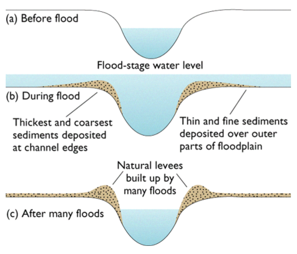
Some of those mimic natural parts of an undisturbed river system. Levees are natural, but they're typically short and are formed from heavier sediments dropped first after flood water overtopped the natural channel. Then a natural levee is built. Distributaries are normal - like the Atchafalaya distributing water from the Mississippi. And floodways and spillways are designed to mimic that process in the absence of the real thing. 

So we captured the mighty Mississippi, locked her in levees, blocked off any water escape routes, and thought everything would be fine. 

It didn't exactly go to plan. The Mississippi has massively flooded many times since the 1850s. 

Flooding is a natural process of rivers, and part of how the rivers built their floodplains and deltas in the first place. So of course, disrupting the natural processes would end up wreaking some havoc sooner or later. 

The 1927 flood is sort of the benchmark by which we measure all Mississippi River flooding. If you look at the NOAA gauge at Baton Rouge, the record listed is 47.28ft which was set on 5/15/1927 (link). That year the river did remarkable things, and it "tore the valley apart" (John McPhee, The Control of Nature).  Hundreds of crevasses (breaks in the levee) appeared in levees from Cairo to the Gulf of Mexico, hundreds of people were killed, 26000 square miles of land were covered by Mississippi River floodwaters, and New Orleans was saved from destruction and despair because some guys blew a hole in a levee to relieve pressure.

The flood of 1927 literally did tear the Mississippi River Valley apart. Yet, by water volume, it wasn't anywhere near to being a record amount of water.

But the river broke through it's confinements and spread out across the alluvial plain, just as nature intended. The power of a major river like that is difficult to harness and possibly impossible to contain forever.

The 1927 flood is what sparked the 1928 Flood Control Act, which ultimately resulted in much more aggressive measures to attempt to control the mighty Mississippi and it's raucous floodwaters. Levees were built higher, dams were built, new water distribution methods were developed, and the river channel was straightened and some loops were cut off. In Louisiana, the Bonnet Carre Spillway was built at the site of previous crevasses in the Bonnet Carre area. They also built the Old River Control Structure, the West Atchafalaya Floodway, the Morganza Spillway, and more structures upriver north of Louisiana.

I could write for days about the confinements and manmade methods of distributing water from Mississippi, but my main point is that all of these efforts to contain the river and then distribute water on our terms, leaves many opportunities for the river to fight back.

In 1927 there was such widespread flooding and destruction that a whole new era of management began. In 1973, a similar thing happened and shuttled in another new era of water management.

The 1973 flood was the turning point into maybe realizing that we don't have the river under control as much as we think we do. The flood was massive, and nearly tore down the Old River Control Structure (I talked about this structure in depth in Part 4 of this series).

After realizing that they had almost lost the structure and then would have lost control of the river (lost from the engineering perspective, anyway), the US Army Corps of Engineers had to regroup and rebuild and only narrowly survived the 1983 flood.

In my own lifetime, I've seen the Bonnet Carre being opened every more increasingly to offset flooding pressures on New Orleans. The Morganza Spillway was opened for the first time in 2011. Every time the river floods and the 30% that is diverted through to the Atchafalaya is also high, the Old River Control is tested again and again. The Caernarvon and Davis Pond Diversions also divert water from the Mississippi, but they provide a flux of freshwater to the surrounding marshes and are not primarily designed to alleviate flooding pressure on the levee system.

But there are areas of the river where natural processes are at work. In 1926, the manmade levees for a 10 mile (ish) stretch on the east side of the river were removed to create the Bohemia Spillway. Here, the river is free to move as it pleases, to overtop its own natural levee in times of high water and spill out into the adjacent marshes. Nature didn't exactly fight back to earn it's freedom in this location, but it's certainly taking advantage of the freedom to rebuild marsh and fill in/reclaim old canals.

In 2011, during a wild flood year, a breach in the natural levee of the Mississippi River in the Bohemia Spillway area developed. "Mardi Gras Pass developed from a breach in the road located at the levee crest in May 2011 to a fully connected distributary of the Mississippi River by March of 2012." (source)

Mardi Gras Pass and the Bohemia Spillway are operating as nature intended - water flows over the natural levee during high water, water disperses out the main channel and into the marsh via Mardi Grass Pass, and marshes are built/nourished/resupplied/maintained. It's a beautiful system, and one we are currently trying to replicate with our spillways, diversions, and floodways.

It's too late to reconnect the natural waterways that were formerly distributaries of the Mississippi River. Bayous Manchac, Plaquemine, and Lafourche [which is also an old Mississippi River channel from ~2000 years ago] are all dammed and disconnected from the river. None of those waterways could be connected to the river without disastrous consequences, surrounded as they are by houses, businesses, and other human activities.

It's totally possible that the Mississippi could break down other defenses, but time will tell. We're currently in an unprecedented river flood so it'll be interesting to see what happens as the snow melts and travels downstream. Ultimately, the river will win. Maybe not this year, maybe not for 100 years, but at some point, I expect the lower portion at least of the Mississippi River will flow freely again someday. 

References:
NOAA Mississippi River real time gauge at Baton Rouge
The Control of Nature by John McPhee
Bonnet Carre Crevasse, Wikipedia

Wednesday, February 20, 2019

Taming the Mississippi, Part 4: The Folly of Man

This is Part 4 in my Taming the Mississippi series.
Part 1: Wetlands Perceptions
Part 2: Riverine Processes
Part 3: Wetlands Values

------------------------------------------------------------------------------------------

“One who knows the Mississippi will promptly aver—not aloud, but to himself—that ten thousand River Commissions, with the mines of the world at their back, cannot tame that lawless stream, cannot curb it or confine it, cannot say to it, Go here, or Go there, and make it obey; cannot save a shore which it has sentenced; cannot bar its path with an obstruction which it will not tear down, dance over, and laugh at.” - Mark Twain, Life on the Mississippi

Despite humanity's best and/or misplaced intentions, nature doesn't always cooperate with what we might want her to do. Sometimes that's disastrous, sometimes that's what is needed, and sometimes we deserved the ensuing chaos. The Mississippi River is not an exception to this rule, rather it is often proving us wrong (or at least attempting to).

There's been quite a few examples of engineering projects gone wrong by natural processes that were unforeseen, or exacerbated by said man-made engineering. Settlers, Native Americans, colonizers, engineers, land owners, and nearly everyone in between has attempted to modify the way water moves in some capacity. 

And therein lies the folly - humans can try to control nature, but ultimately nature will win. In this case, the mighty Mississippi is far mightier than the best team of engineers. That doesn't seem to stop us as a whole from trying, so let's explore all the ways in which these follies have been enacted. 

In my research about the beginnings of the levee system, I discovered an article by the US Army Corps of Engineers (USACE), which says: "Levees are the backbone of the flood control plan for the Mississippi River and Tributaries (MR&T) project. The system protects the vast expanse of the developed alluvial valley from periodic overflows of the Mississippi River." There's many eye opening things about this statement and a few things I'd like to point out. 

1) Levees being the main part of the flood control plan is clearly not an adaptive plan at all because levees are by design immovable. So that's a problem, and a one size fits all solution doesn't work in water management. 

2) The idea that the levees protect the alluvial valley from the river is completely laughable. It does not such thing. Levees protect PEOPLE from WATER, and DISCONNECTS the river from it's home alluvial valley. The alluvial valley was literally formed by the river. Alluvial comes from the world alluvium, meaning "a deposit of clay, silt, sand, and gravel left by flowing streams in a river valley or delta, typically producing fertile soil." The Mississippi Alluvial Valley (MAV) was literally formed by the river. It's as much a part of the river system as the water itself. So that's insane.

3) This concept of managing something as powerful as the Mississippi River is the true folly of all of this.

Moving on - the history of levees around the Mississippi originated as a patchwork of smaller earthen man-made levees that contained flood waters in a disjointed effort. According to the USACE, the first levees were started in the year 1717. New Orleans was but a twinkle in the eye of the French colonials, and wouldn't be founded officially until the following year. Most of the levee work was short (~3 feet tall), and done by landowners patchwork style.

In 1803 the new country of the United States bought modern day Louisiana, including New Orleans, and much of the land into the heart of the modern day country through the Louisiana Purchase. This allowed the US to double in size practically overnight and to gain control of the valuable port of New Orleans. Once the land definitively belonged to the Americans, settlement exploded. New settlers raced to settle lands, often choosing floodplain lands highly susceptible to flooding (another folly), instead of settling less susceptible lands and leaving the natural floodplain to just do important floodplain things. So these new settlers then in turn had to build levees to protect their new home lands (more folly).

Louisiana gained statehood just a few years later, in 1812, and in that short amount of time an insanely extensive system of levees had been constructed. To be fair, in the 1800s, as we discussed in Part 1, wetlands were viewed as evil and dangerous, and land was viewed as a commodity to be controlled. So modifying the landscape to meet your own perceived needs was the norm, and it follows then that building levees was the pervasive viewpoint and totally common. Hindsight is 20/20 and now we can only wonder what the coast of Louisiana would look like had the land and river been left to her own devices.

Levees evolved over time from short hand made structures a few feet tall built in the 1700s to the larger modern day monstrous levees we have today. The USACE report has a great graphic illustrating this (source):


Over and over again, year after year, flood after flood, the levees were destroyed, overtopped, breached, or ruined in some way. And reactively and predictably, whoever was in charge of managing the levee system at the time responded by building bigger, sturdier, crazier levees to contain the Mississippi's floods.

But then, in 1927, the eventuality happened. The perfect storm of rainfall and snow melt overwhelmed the system. The aptly named Great Mississippi Flood of 1927 took control.

It started in summer 1926 with heavy rains in the Midwest, and tributaries swelling to or over regular capacity. The flooding continued into the spring expanding beyond fathomable dimensions. Rivers set records that have yet to be broken to this day. For example - the Mississippi River was 60 MILES WIDE just south of Memphis TN [source] in May 1927. Personally I can't even begin to picture that it's just that insane. This trend of ever increasing water depths and widths continued through the winter of 1926 into 1927 and reached it's literal breaking point in the spring of 1927.

In April of 1927, New Orleans was receiving heavy rainfall and starting to flood several feet deep in places. At that point, a group of wealthy bankers decided something needed to be done to protect the city from more water that was coming downriver. They took matters into their own hands and dynamited a hole in the levees at the little town of Caernarvon, 13 miles downriver and southeast of the city. They flooded St Bernard Parish's more rural areas in an attempt to save the city of New Orleans. As it turned out, and probably unknown to these people, there were a few levee breaches above New Orleans around the same time.

Ultimately by the end of the 1927 flood, once waters started to recede, around 70,000 sq km (27,000 sq mi) of land was flooded during the event and 700,000 people were displaced.

In response to this massive catastrophe, politicians passed the Flood Control Act of 1928 which essentially gave the US Army Corps of Engineers (USACE) the power to try to tame the Mississippi. Levees were built, floodways created, water was channeled and the whole thing was called Project Design Flood. The USACE built the Bonnet Carre Spillway (completed in 1931), the Old River Control Structure (completed in 1953), and the Morganza Spillway (completed in 1954). Seemingly flooding was controlled.


Seemingly.

In 1937, only 10 years after the 1927 Flood, the USACE's newly built structure at the Bonnet Carre Spillway were put to the test when the bays were opened for the very first time. The Bonnet Carre structure was built at the site of the Bonnet Carre Crevasse, a levee breach that opened up in 1871 above the city of New Orleans. They repaired the levee years later but then created the spillway at the site of the breach. The location is fantastic in my opinion because it channels fresh river water into marshes and into Lake Pontchartrain where it can offset saltwater intrusion and nourish the surrounding wetlands. But that's another story. The spillway is designed to relieve river flooding pressure on New Orleans, to essentially protect the city.

The next major Mississippi River flood was in 1973. By this time the Old River Control Strucure (ORCS) and the Morganza Spillway had both been completed and they are both in the same general area between Vicksburg MS and Baton Rouge LA.

The ORCS is designed to divert a set amount of river water from the Mississippi into the Atchafalaya at all times, with the intention of keeping the Mississippi in it's current channel. USACE studies have shown that left to its own devices, the Mississippi would change course from its current channel to the Atchafalaya's channel, as it is the shorter route to the Gulf of Mexico. Rivers changing course is a totally natural process but would create many problems for society if it happens. So the ORCS is designed to keep the river locked into it's channel and to keep the Atchafalaya with a certain amount of water.

The Morganza Spillway is the other part of that river control network, and is high and dry far away from the river the majority of the time. It's designed to be used in times of extreme flooding to divert water away from the Mississippi and into the Atchafalaya River, to bypass the downriver cities of Baton Rouge and New Orleans.

The 1973 flood was the biggest test of the USACE river control system since the 1927 flood. It was the largest volume of water since then, and both the Bonnet Carre and Morganza Spillways were opened. Winter precipitation in the Midwest, followed by high volumes of spring rainfall, and then winter snow melt all compounded to this historical flooding. The pressure on the ORCS was so strong that the structure nearly failed entirely - the base started to erode and the concrete was damaged. The structure held out and the Mississippi did not change course, but it was a closer call than anyone would have liked.

All the structures ultimately survived the 1973 flood, barely, and damages were repaired for future use.

The next major flood was in 2011. The first time the Morganza Spillway was opened in my lifetime was during this 2011 flood. It has only been opened twice in its history so this was quite the spectacle. We watched the live news footage of them opening the gates and the water rushing through. PBS has a nice short video if you'd like to watch it for yourself (here). 

Yet again flood waters were funneled into the Atchafalaya Basin via the Morganza, down the Atchafalaya River via the ORCS, into Lake Pontchartrain via the Bonnet Carre, and down the course of the Mississippi River via the USACE levee system. This has become the modus operandi in flood events, and will likely become more frequent (if you ask me).

The idea that we as humans can control natural processes as mighty as the Mississippi River is the folly part of the whole scheme. Nature wins, nature always wins, and it may take awhile but nature will likely win in this scenario too at some point. There's legitimate concerns that the next big flood could bring down the ORCS. That would mean the Mississippi could abandon it's own home channel and would likely commandeer the Atchafalaya's channel. The potential consequences of all of this are wide-ranging, enormous, unfathomable, catastrophic, and possibly inevitable.

I'll discuss the ways in which nature has fought back across the Louisiana coast and in particularly what the River has done in response to human intervention in upcoming part(s) of this series!

Sources & Additional Readings:
History of the Lower Mississippi Levee System US Army Corps of Engineers, accessed 2/18/2019
History of Levee Building on the Mississippi River Climate-policy-watcher.org, 12/4/2018
The Louisiana Purchase Wikipedia, accessed 2/18/2019
Caernarvon, Louisiana Wikipedia, accessed 2/18/2019
Great Mississippi Flood of 1927 Wikipedia, accessed 2/18/2019
Mississippi flood of 1973 Wikipedia, accessed 2/20/2019
Project Design Flood Wikipedia, accessed 2/20/2019
Morganza Spillway is Opened PBS NewsHour via YouTube

Monday, February 18, 2019

A Letter to Aldo Leopold

Dear Aldo,

I just finished reading A Sand County Almanac for the second time in my life. I read it the first time in college, when it felt like required reading. I retained a sense of wonder from it, but not much else. I recently started a quest to read a conservation related book every month and February 2019 was your classic work. This time round, I learned so much more. Possibly because I chose it out of my own free will instead of a sense of obligation. Possibly because I am more in tune with the world around me and my own role and sense of identity than I was years ago. Possibly also because I care more deeply than I did before, if that is possible.


This past week was spent with a group of women who shared very similar ideals to me, in the broad sense, though we all gathered from very different backgrounds and life histories. As we backpacked through the Galiuro Wilderness, I kept hearing your voice in the background, whispering to me about the value of wilderness and respect for the land, and the importance of every aspect of the community. My personal sense of wonder at the land I was exploring was only enhanced by thoughts of how you would perceive the area. Would you have enjoyed it in the same way that I did? Am I capable of the deep reflection and care for this land that you had for your sandy farm? Do I truly understand what it means to be a human, aware and responsible of my surroundings, and can I do the best possible work to achieve the best possible future for our lands?


I hope so. I hope that everything I am trying to do would make you proud. I hope that my conservation efforts are not in vain. I hope that by appreciating wilderness and public lands and doing it in a nonconsumptive way will support the cause so that others in the future may also have that ability and luxury. The land is not mine. It is not ours. As you say, we belong to the land, the land does not belong to us. Being a part of the community is valuable, in an intangible and hard to describe way. Economic value is not the only value worth having.


This past week in the wilderness definitely left me with a sense of awe. I had private conversations with the wind, the trees, the birds, the rivers, and the rocks. I gently touched Douglas firs and manzanitas as I hiked, saying hello and also thanking them for their presence. I felt the heat emanating from the red rock as I summited a mountain. Rock that had been there for thousands of years, simply standing the test of time, and I was lucky enough to be party to its presence and enjoy some warmth and greetings from them.


I feel very grateful for the lessons of respect your writings have instilled in me. I can only imagine what I will learn from you when I dive further into your works and life lessons. It’s difficult for me to fathom what else you might have accomplished after A Sand County Almanac, and though I cannot know for sure what it could have been, I am confident that the world is a little worse off for your departure.


Thank you for imparting wisdom on me and to anyone who has been fortunate enough to find your writings, and anyone perceptive enough to fully absorb them as I feel I have. It’s truly transformative and I am inspired by your dedication to journaling and essays, and I hope I can commit to doing that in my own life in the way that you have. Thank you for everything!

Friday, February 8, 2019

Zero Waste update 2.0

I realized earlier that I never did outline my zero waste goals, as alluded to in my shopping ban announcement post. I have a few problem areas that I am trying to address, and I'm acknowledging in advance that I will probably not make it to completely zero waste in the next few months. But I can do as much as possible!!!


1. Cat litter boxPreviously I had been using standard cat litter in my cat's box. I have always felt so wasteful with it. I found walnut shell pellets at the local shop and transitioned my cat over to those. He doesn't really seem to care and uses it just fine! The main problem I had with regular litter is that I felt so wasteful just throwing it all in the trash. But with these walnut shell pellets I can scoop his box, put it in a pail, and put it in my compost bin! NOTE: I do not put my compost on any kind of food producing garden so I don't have to worry about some sort of contamination to food stuffs. I'm a terrible gardener. I just compost to deal with my own kitchen scraps instead of letting the landfill deal with it.


2. Cat food bagsMy cat is on a very specialized diet for his chicken allergy and kidney problems. It's made by Royal Canin and turns out that Terracycle does a Royal Canin recycling program for the packages! Win! I haven't actually mailed any of my bags in yet but I'm stockpiling and knowing that I have a place for them is comforting.


3. Bathroom products - contacts, toothpasteTerracycle also wins here too. They have various mail-in programs for contact containers & contacts themselves, and for toothpaste tubes & toothbrushes. Check it out!


4. Subway cups
Subway fixed this for me!! The other day when I went in there (my once weekly lunch spot) they had reusable cups! $2.99 for the cup up front, then half price drinks for all of 2019. So even getting a combo, my drink part of that will be cheaper. So I'll save money eventually, though that's not really the important part. I'll be using fewer plastic cups! I can recycle them but better to not use them in the first place.

Friday, February 1, 2019

Taming the Mississippi, Part 3: Wetlands Values

Part 1: Wetlands Perceptions
Part 2: Riverine Processes

------------------------------------------------------------------------------------------

We've discussed how wetlands have been perceived through time, across eras, and by different communities of people. We've discussed just how rivers work and build land and talked specifics of the Mississippi River in both cases. Next logical step is the value of wetlands. Intrinsic, economic, recreational, commercial, ecological, and everything in between.

In the past (as discussed here) wetlands have been essentially abused. They've been logged, drained, filled, channeled, and destroyed in all manner of ways. All for the "good" of society. But it wasn't really for the good of the people but at the expense of the people. It just took us all these years to discover the true values of wetlands.

Everything is interconnected. Dredging a canal over there could allow salt water to intrude into a fresher water marsh over here and change the entire species community over time.  Building levees blocks off the natural flow of water and may actually cause worse flooding, just in other and maybe unintended areas. The point is - we as humans have a habit of tinkering with a system that we don't fully understand before we even have a chance or take the time to fully understand it. The same with wetlands. We now understand the full values of the resources we have drastically altered, but often that information doesn't get relayed to the general public. So here's my shot at relaying all this!

Value 1: Water Filtration
Wetlands are a network of stems, leaves, and root masses. As water flows into a wetland, it's naturally slowed down by that network. As the water moves more slowly, sediments that were suspended in the water column begin to drop out and settle on the wetland surface instead of riding along the current. Larger sediments drop first (like sand) and smaller finer sediments drop last (like clay). The slower the water moves the finer the sediments that settle out.

Sediment trapping in this process is vital to wetland health. Wetlands naturally subside (compress or compact) over time, and the influx of fresh sediment naturally offsets that so that wetlands can maintain their elevation. Without accretion of sediments, wetlands sink and as a result are flooded more often because of the lower elevation. Increased flooding impacts plant health and eventually the wetland will just sink away and cease to exist. So when wetlands get access to water to remove sediment, its a win-win. Wetlands get fresh sediment, and the water gets to carry less material.

Not only do wetlands allow sediments to settle out by slowing water down, they also absorb nutrients from the water. The stems and leaves of wetland plants are capable of absorbing nutrients like nitrogen and phosphorous. Nitrogen and phosphorous commonly end up in riverine systems because they prevalent in agriculture areas. Phosphorous is used in most fertilizers and applied to crops and farms regularly. Nitrate is a form of nitrogen that also a byproduct of fertilization. Natural levels of nutrients can be absorbed by plants and regular levels of algae, but the excess in nutrients causes problems downstream.

The Mississippi River drains 41% of the United States, including nearly all of the Midwest, which has a very high concentration of farming and agriculture. Nutrient rich water in this region runs off the land, into streams and rivers, and ultimately into the Mississippi. That water flows down river into the Gulf of Mexico. All the extra nutrients in the water is a food source for phytoplankton, which leads to rapid population growth. This process of increased nutrients leading to algal blooms is called eutrophication. In the hot summers the water of the Gulf gets quite warm, nutrient levels are high, and algae blooms rapidly and unchecked, dissolved oxygen in the water is depleted, marine life cannot survive, and ultimately we end up with a "dead zone". Historically, nutrient levels were not nearly as high as they are in modern times. Fertilizing for agriculture, manure runoff, and sewage all find their way into the river. It's too much for the system to handle naturally anymore and we end up with these crazy complications like the ever larger Gulf of Mexico Dead Zone.

Furthermore, historically water from the mighty Mississippi would have spread out and flowed across wetlands more gradually before ending up in the Gulf of Mexico. In the natural system, river water would get filtered, and the wetlands would get access to nutrients and sediment. These days, the river is channeled rather narrowly straight into the Gulf with limited connected flow, and even that flow is highly managed. As a result, wetlands don't get access to river water nutrients and sediment as much as historically, and river water doesn't get filtered naturally by the wetlands either.  It's a lose-lose for the river and the wetlands.

Value 2: Storm Surge Protection and Buffering
It's difficult to put an economic value on an environmental service like storm surge reduction. There's many factors that go into play. What are the areas being protected? If it's coastal New Jersey versus a tiny community that's a vastly different economic amount, but still important protection either way. How much infrastructure damage was avoided? That includes roads, bridges, maybe oil and gas infrastructure, homes, businesses, etc. How many homes did not flood because of the storm surge reduction? If 1000 homes were at risk, but now 750 are now protected then that's a huge benefit (I made these numbers up for easy comparison).

The rule of thumb from an US Army Corps of Engineers report is that storm surge is reduced by 1 foot for every 2.7 miles of marsh. That's a round number but many things influence whether that is true or not (like wind speed, storm speed, wind direction, precipitation, marsh health...). It's definitely situation and location dependent. But if we just ballpark and say 1 foot of storm surge is reduced for every 3 miles of marsh, then we still need a substantial amount of healthy contiguous marsh. Storm surge from hurricanes can often reach 15-20 feet high, so if we have a 15 foot storm surge we need 45 miles of marsh or more to fully absorb that surge and provide adequate protection.

Besides extreme storm surge events from named hurricanes, wetlands also absorb water from more regular high water events. In Louisiana, the Mississippi River has several diversions where water can be diverted from the river to the surrounding wetlands. That has a variety of benefits, but this is done to relieve flooding stress on levees and cities. These outlets funnel water into the wetlands where it is slowed down and absorbed. Water moves much slowly through a wetland ecosystem than a channeled river. Wetlands also absorb precipitation, overflow from rivers/bayous/creeks with natural boundaries, and any other surface water. They are effectively sponges.

Reduction in wetlands surrounding populated areas has many negative effects, many of which are only realized many years later when it's far too late to resolve immediately. I talked about this some in Part 1: Wetlands Perceptions. But in this regard, the shorter distance from cities to open water is detrimental, particularly during hurricane season. Water simply has nowhere to go and is forced into human society instead of being completely or primarily captured by the natural wetlands.


Value 3: Fisheries
Wetlands play a vital role in fisheries, though it may not seem like it to the casual observer. Many species of marine (as in offshore) fish come inland to spawn in wetlands, because wetlands provide cover, protection, and food for young fish before they head back out to their marine homes. "Over 75% of Louisiana’s commercially harvested fish and shellfish species are dependent on wetlands. Coastal wetlands provide valuable breeding, spawning, feeding and nursery grounds for many of these species at some point during their life cycles" (source).

Young fish and shellfish may feed on algae, plant matter, insects, other young fish, and the detritus (partially decomposed plant matter) present in the wetlands. Each species has different needs and the buffet offered up by wetlands is bountiful. As an example, small fish such as menhaden eat plant detritus. Bigger fish (tuna, trout, drums) may eat menhaden. Continuing with menhaden as my example, they are also food source for wildlife.

Admittedly I'm not much of a fisheries person myself, but I do know that without wetlands to provide habitat and cover for spawning, many species would be severely impacted. That would have a chain effect for fisheries, commercial and recreational fishing, and Louisiana's economy.

Value 4: Migratory Bird Habitat
Migratory birds worldwide use a system of routes, called flyways, to get from breeding grounds to wintering grounds and back again. The Mississippi River delta and alluvial valley overall is part of the Mississippi Flyway. Birds that winter in South America and breed in Northern Canada (and every midway distance in between) may use that to cross over the Gulf of Mexico. The coastal wetlands and barrier islands of Louisiana are important on the northward migration because they are literally the first land many birds meet after crossing the Gulf. If you time it right, and you bird watch from the beach in Grand Isle LA, you can see many species of birds diving into the first available vegetation as they finish the water crossing. As wetlands deteriorate and recede, the crossing becomes just that much longer.

Related barrier islands, which are part of the coastal wetlands system, provide critical habitat in the same manner. The disappearance of those vital strips of land is a whole other set of issues that I won't discuss in depth here. But suffice to say that loss of wetlands makes it harder for migratory birds as they land on their northerly journey.

Even with wetlands presence, habitat quality may suffer. There's a big difference between a happy healthy salt marsh full of native plants and a shrubby degraded patchy semi-wetland. If habitat suffers, then the whole food chain is probably suffering. Everything is interconnected. Birds that use this migratory flyway include everything from hummingbirds, songbirds, raptors such as my fave the swallow-tailed kite, waterfowl, and waterbirds.

And that's only migratory birds! There are also many resident species that use wetlands, including our relatively new nonmigratory experimental population of Whooping Cranes. There's also rails, waterbirds, and more that don't migrate and call Louisiana's wetlands home year round. Protecting, conserving, and managing habitat for migratory birds also will automatically encompass the needs of nonmigratory birds as well. 


Value 5: Recreational Opportunities
There's a reason that Louisiana is called Sportsman's Paradise - we are flush in outdoor recreational opportunities of the aquatic kind. Hunting, fishing, swamp tours, offshore fishing, kayaking, even kayak fishing. The opportunities for recreation in the coastal wetlands are vast. 

Hunting is a big deal here, and waterfowl is probably the most common type of hunting taking place in Louisiana's wetlands. It's a big deal when the first teal start to show up in August and September because winter is coming! Avid duck hunters wait excitedly for this time of year and every hunter I know will keep records, report retrieved bands, buy ammo and guns, buy gear, buy duck stamps/WMA permits/hunting licenses. Hunters pay taxes (11% on guns/ammo, for example) that directly funds wildlife and habitat conservation and management through programs like the Pittman-Robertson Act. Hunters have to buy federal duck stamps, and nearly 98% of that money goes directly to the Migratory Bird Conservation Fund, which uses that money to create, expand, and manage National Wildlife Refuges. So money from hunting goes directly to protecting wildlife habitat, so it's a self fulfilling system in a way. Hunters are the original conservationists - they want to hunt wildife, so they want to conserve habitat and the species in the long term to protect the species, habitat, and sustainable hunting opportunities.

But waterfowl hunting isn't the only hunting taking place. There's waterfowl, deer, hogs, alligators in a strict season, nutria... It's practically a buffet out there. Responsible population management will provide hunting opportunities for interested people, keep populations to a manageable level, and bring in money from taxes and sales.

Fishing is also a big deal. I talked some above about fisheries and habitat, but commercial and recreational fishing is a big market. People travel from all over to go on a guided fishing trip in the wetlands of Louisiana. People fish inland and offshore, for speckled trout and red snapper, guided or not, in a motorized boat or kayak, and in any number of ways. Commercial fishing is also important because it is an important part of our economy. According to Louisiana Seafood, the industry is worth $2.4 BILLION annual for Louisiana's economy (source). That includes shrimp, oysters, crabs, crawfish (that's farmed & wild caught), and alligator (farmed and wild caught). The seafood fishing industry is built into the culture, the diet, the festivals, and the mentality of the coastal population.

Summary
As you can see there are so many ways to value wetlands. It's difficult to put an exact monetary value on something like storm surge protection, but you can put an economic value on the house that didn't get destroyed because of the extra 10 miles of wetlands providing protection. It's not exactly a black and white system, but more wetlands = more benefits. There's really no downside to more wetlands. You just can't have too many wetlands. So no matter which aspect of these few that I listed you value the most, providing for that value often provides for all the other values. It's similar to managing for a keystone species in wildlife ecology. If you want to provide habitat for migratory birds and don't much care about alligator hunting, you'll still provide alligators with good habitat by providing habitat for migratory birds. They use different parts of the wetlands but both benefit from habitat conservation or restoration. More wetlands please!


Additional Reading and Sources:
Water Filtering of Wetlands National Park Service, accessed 1/25/2019
Fertilizer Runoff Overwhelms Streams and Rivers--Creating Vast "Dead Zones" Scientific American, 3/14/2008
Eutrophication Wikipedia, accessed 1/25/2019
Dead Zone (Ecology) Wikipedia, accessed 1/25/2019
Nitrogen and Water USGS, accessed 1/25/2019
The Gulf of Mexico Dead Zone Carleton College, accessed 1/25/2019
What Causes Ocean "Dead Zones"? Scientific American, accessed 1/25/2019
How Do Wetlands Filter Water? Sciencing.com, accessed 1/25/2019
Cleaner Water The Wetlands Initiative, accessed 1/25/2019
Louisiana Coastal Wetland Functions and Values LAcoast.gov, accessed 1/25/2019
Menhaden Wikipedia, accessed 1/25/2019
Storm Surge Reduction by Wetlands accessed 2/1/2019
Wetlands Provide Hundreds Of Millions Of Dollars In Storm Protection Fast Company, 10/2/2017
Understand - Conserving Coastal Wetlands for Sea Level Rise Adaptation NOAA, accessed 2/1/2019
Wetlands and barrier islands: Our communities’ first line of defense RESTORE, accessed 2/1/2019
The Value of Wetlands in Protecting Southeast Louisiana from Hurricane Storm Surges E Barbier et al, 2013, PLOS One
Mississippi Flyway Wikipedia, accessed 2/1/2019
Mississippi Flyway Audubon, accessed 2/1/2019
Pittman-Robertson Act Wikipedia, accessed 2/1/2019
Duck Stamp Dollars at Work US Fish and Wildife Service, accessed 2/1/2019
Whooping Cranes Louisiana Department of Wildlife and Fisheries, accessed 2/1/2019
Louisiana Seafood Industry Louisiana Seafood, accessed 2/1/2019
What Does the Economy Stand to Lose If We Don’t Restore Louisiana’s Coast? RESTORE, accessed 2/1/2019
Coastal Wetlands: Too Valuable to Lose NOAA Fisheries, accessed 2/1/2019
Louisiana seafood industry's economic impact compared to other states NOLA.com, 3/11/2013
Value of Wetlands The Wetlands Initiative, accessed 2/1/2019
Why are Wetlands Important? EPA, accessed 2/1/2019

Thursday, January 24, 2019

My River

In the summer of 2005, I worked at the St Croix National Scenic Riverway in Wisconsin. At our training session we were asked a very interesting question: If we had to identify with one river, one that we felt connected to in our lives or that was our favorite, which river would it be?

What river do I identify with? As we went around the room answering, I thought about it. Up to that point in my life, I hadn't spent a large amount of time on any particular river. I had never really thought about it. I didn't really identify with any particular body of water. But as I kept thinking about it, I realized how wrong I was. There was one river that was always there and it was such an undercurrent part of my entire life that I took it for granted without really considering it. But my river was always there.

My river is the Mississippi River.

The mighty Mississippi during record flooding in 2008, in Baton Rouge

Some of my earliest memories are of the Mississippi river levees in St Charles Parish in Louisiana, where I spent half my childhood. And of playing on the levee at the horse barn in Orleans Parish. The river was right there, just a very quick bike ride away for the first 9 years of my life. From the street in our neighborhood you could see ships towering over the levees when the river was high. And when the river was low, you could go over the levee to the river side and play in the "batture" - which is the French word for "shoal". All of that brings us around that the batture is "an area of shallow water, especially as a navigational hazard" (source) and that basically sums it up. It's an area that's dry during low water, often has flood tolerant trees and shrubs growing there, and would definitely be a navigational hazard during higher water. In the photo above the batture is from where I was standing to about the trees. The main channel of the river is beyond that.

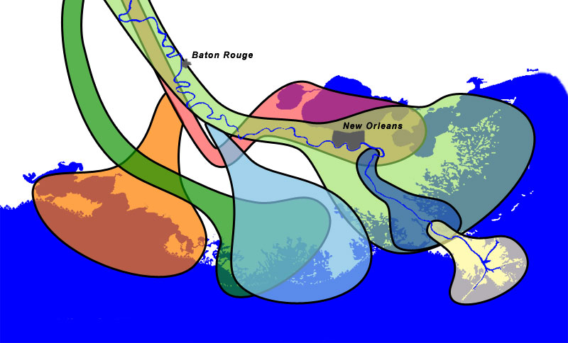
When I was about 9, we moved further away. Not that far, not really, but away from the current banks of the Mississippi. And while the Mississippi wasn't a daily sight, let's be honest, south Louisiana would not be the place it is without the Mississippi. Lake Pontchartrain is an old Mississippi River delta, and the north shore of Lake Pontchartrain was formed by the Mississippi as well. So even though I didn't see the river daily again until college, I lived on the northshore, which was literally land shaped by the river. So really, I was still connected to it even though I wasn't aware of it daily. At the time I didn't know that Lake Pontchartrain is an old abandoned delta of the Mississippi, but it makes the time driving across it on the Causeway that much more poignant to me.

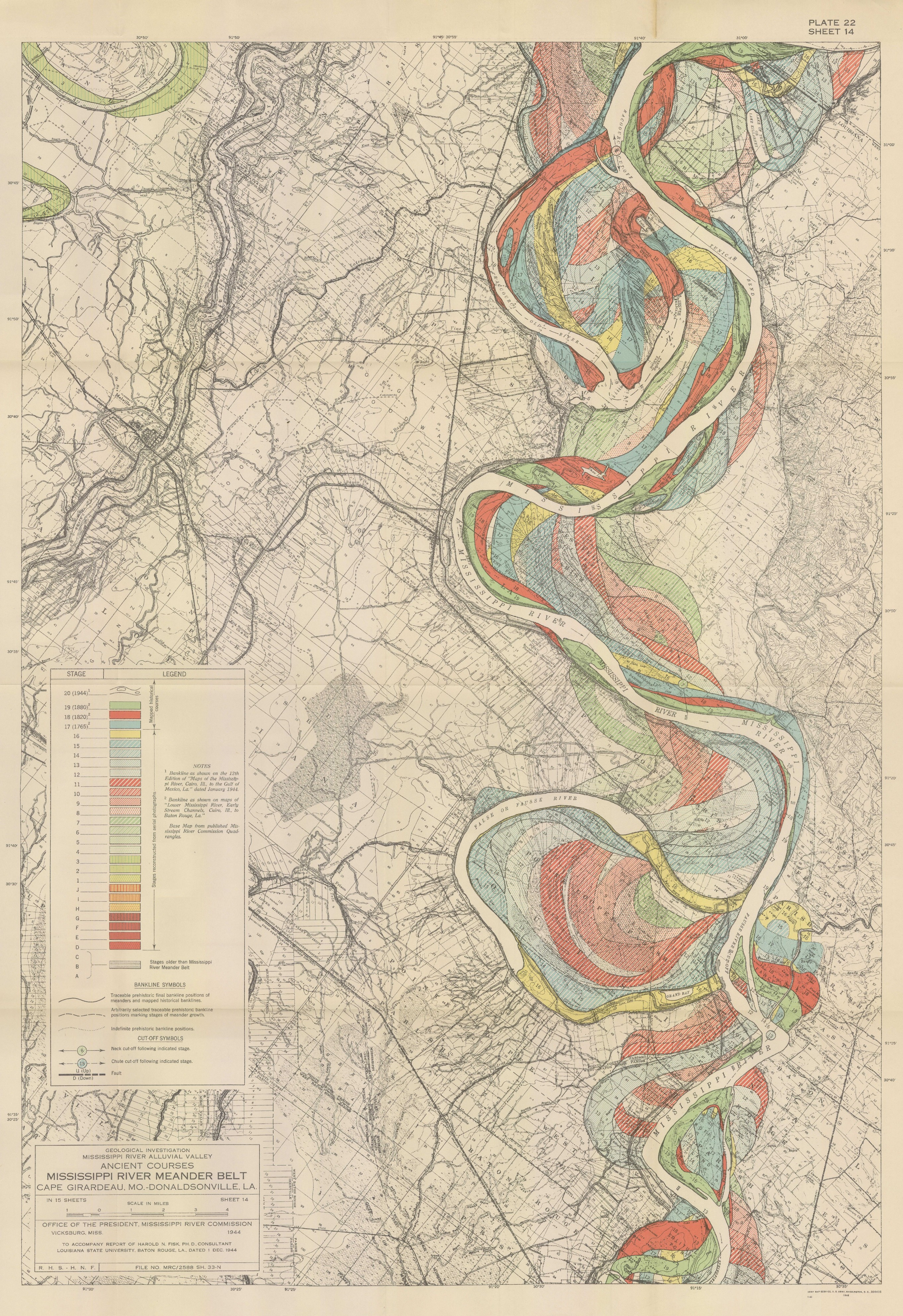
And then I moved to Baton Rouge when I was 18. I lived not even 2 miles from the river most of the time I have lived here (I now live 5.8 miles away if you're wondering). I learned in college that Highland Road is called that because it's on the first high land from the river. In fact, this road is placed conveniently on the natural levee that the Mississippi created on it's own before we built man-made levees. Natural levees are formed when a river overflows it's normal channel and spreads out, slows down, and drops it's sediment, creating ridges - natural levees. And Highland Road is on that natural levee, which I had never thought about before but for anyone familiar with that area, everything west of that road up to the river is much lower and floods so easily, including the LSU campus and nearly every apartment I had in Baton Rouge. 

The summer of 2005 when I went to work in Wisconsin, I didn't really think about it at the time but I basically went straight north along the Mississippi to get there. The Namekagon River, where I spent much of my time, is a tributary of the St Croix River. Which is a tributary of the Mississippi River. It all comes full flow. Not full circle though, because rivers don't work like that. It's really remarkable to me how things can be so interconnected and our lives be so influenced by factors that we sometimes aren't even aware of it.  

Just the other day, I hadn't seen the river in a few days and kind of just wanted to say hello. It was wrapped in a thin haze of fog, and looking awfully high for January, but nonetheless it's still my river. 


So all my life I have either lived practically within sight of the river or on land the river created a long time ago. I'm amazed at how my river has influenced me so much - my memories, my life, my state, my passions, my fears, my career, and the land I've always lived on. What is your river and how has it influenced you?

Wednesday, January 9, 2019

Taming the Mississippi, Part 2: Riverine Processes

Part 1: Wetlands Perceptions
------------------------------------------------------------------------------------

The whole point of this series is to discuss all the ways the Mississippi and coastal Louisiana has been impacted by everything in the past to create the current situation. You really can't talk about the Mississippi River and ignore the wetlands, and vice versa. One created the other, and they are interconnected, interdependent, and yet so very very different.

But for this Part 2, I want to focus on riverine processes. 

Rivers have a few basic parts: the headwaters, the channel, and the mouth. 

Rivers are born from their headwaters, and continue their journey from there. The mighty Mississippi springs to life from a lazy little outflow of Lake Itasca in Minnesota, and slowly winds through some beautiful wetlands as it begins its long meandering journey to the Gulf of Mexico. Some rivers start from glacial melt, underground springs, or as a branch from other rivers (these are called distributaries). 

The mouth of the river is where deltas often form. Not every river creates a delta, but the Mississippi does/did, and an expansive one at that. We often call it the birdsfoot delta, in that the delta is a bit far away from the main portion of the coast and looks like a leg and bird foot. The Atchafalaya River (a significant distributary of the Mississippi) has a beautiful delta that is healthy and growing and wonderful.

The flow of the river carves out the channel, and the main body of water often stays in that channel. However, during flood stages, the river may swell up and overtop its natural banks and water will spread out along the floodplain. Hence why it's called a floodplain - it's literally the flat(ish) areas where flood waters spread out. During flood stage, waters spread out and slow down, and drop sediment. Coarser sediments that were suspended in the water column drop out first because they are heavier. So sands drop out first, and clays last. So then you end up with a natural levee along the river bank.


Since we're talking about the Mississippi, here's an example of that:

There is no "original" channel of the Mississippi River. Not really. It has meandered all over the place for most of its length. But, in Baton Rouge, it's moved east and west of its current location. In one of those more easterly renditions, it created a natural levee that is still visible today. And most people probably have no idea. Highland Road, which runs through the LSU campus, is a natural ridge. It is an old natural levee of the Mississippi River. If you live around here, next time you drive across Highland Road from east to west, and notice how the land drops off on the western side as you head towards the river. These days, the river is contained in levees a mile or more away from there,  so no longer uses that natural feature.


Within the water column in the river channel, rivers can carry many different things - physical debris, sediment, nutrients, flood water, pollutants, and fresh water or salt water. These can all have different effects at different parts of the system.

So rivers carry sediment in some capacity, and in that vein they can cause erosion and deposition along the channel. That's why river channels move over time, or sandbars shift back and forth, and why shallow rivers used for navigation need to be dredged. The sediment is ever moving.

I literally cannot have said it more clearly myself, so here is how deltaic wetlands are formed:

"Deltaic formation begins as sediment laden river water reaches the ocean and slows down causing much of the sediment to drop out of suspension. Over time this accumulation of sediment leads to the formation of bars and shoals that further divert the water, causing increased deposition. Flooding causes increased sediment loss, leading to the formation bars and shoals extending above sea level. This newly-formed land is colonized with vegetation, which leads to further deposition and speeds up the land-growing process. Floating mats of vegetation form causing the water flow to slow and drainage becomes sluggish. The large amounts of vegetation and low flow cause anaerobic conditions to form." [source: Wetland Formation]

Over time, these wetlands are self fulfilling. Wetlands capture sediment, and in turn build more wetlands. It's a beautiful system. This process is how southeastern Louisiana's wetlands were formed. As the Mississippi River swung back and forth over thousands of years (also known as avulsion), this process repeated over and over across many former deltas. What's left today is a vast system of coastal wetlands [which has it's own set of problems, to be discussed in a future part].


The river has been pretty settled in the current channel for a few thousand years now, and would love to switch course (if rivers had emotions). However, we have pretty effectively captured the Mississippi and forced it to stay on its course to our own liking. I'll discuss this more in depth in Part 4.

Stay tuned for Part 3, where I discuss all the values (economic, recreational, societal, environmental, and otherwise) of these coastal wetlands that were created by the Mighty Mississippi!

Note: 
For the purposes of this series, the lower Mississippi and how it has formed the coastal wetlands of Louisiana are the main focus. The channel has shifted over time above Baton Rouge and plenty between there and Cape Girardeau (see the Fisk maps from 1944). I also acknowledge that different sections of the river have different challenges and benefits. 


Additional Information and Sources: 
River National Geographic, accessed 1/1/2019
Should I trust that levee? Missouri S&T University, accessed 1/9/2019
Harold Fisk 1944 Maps Radial Cartography, accessed 1/9/2019
Wetland Formation accessed 1/9/2019
Mississippi Delta Lobes Wikimedia, accessed 1/9/2019
Mississippi River Delta Wikipedia, accessed 1/9/2019
How the Delta formed Restore, accessed 1/9/2019