Showing posts with label Taming the Mississippi. Show all posts

Monday, March 18, 2019

Taming the Mississippi, Part 5: Nature Fights Back

This is Part 5 of the Taming the Mississippi Series.
Part 1: Wetlands Perceptions
Part 2: Riverine Processes
Part 3: Wetlands Values


"With walls alone, one could only build an absurdly elevated aqueduct. Resistance times the resistance distance amplified the force of nature." - John McPhee, The Control of Nature


In part 4 I talked about all the structures and projects that we humans have built in our folly filled efforts to tame the Mississippi. Mainly those are hundreds of miles of levees, multiple floodways, spillways, damming of distributaries, rerouting of the main channel... The list of what we have built and the trouble we have engineered for ourselves is lengthy. 

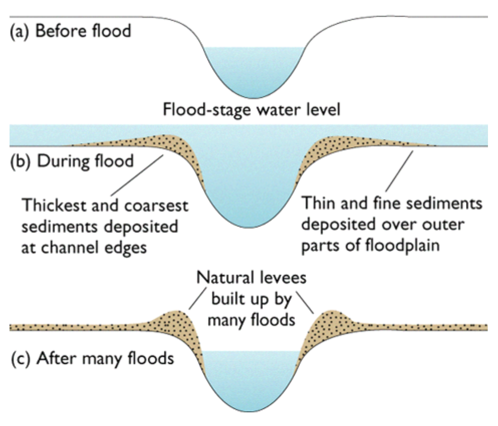
Some of those mimic natural parts of an undisturbed river system. Levees are natural, but they're typically short and are formed from heavier sediments dropped first after flood water overtopped the natural channel. Then a natural levee is built. Distributaries are normal - like the Atchafalaya distributing water from the Mississippi. And floodways and spillways are designed to mimic that process in the absence of the real thing. 

So we captured the mighty Mississippi, locked her in levees, blocked off any water escape routes, and thought everything would be fine. 

It didn't exactly go to plan. The Mississippi has massively flooded many times since the 1850s. 

Flooding is a natural process of rivers, and part of how the rivers built their floodplains and deltas in the first place. So of course, disrupting the natural processes would end up wreaking some havoc sooner or later. 

The 1927 flood is sort of the benchmark by which we measure all Mississippi River flooding. If you look at the NOAA gauge at Baton Rouge, the record listed is 47.28ft which was set on 5/15/1927 (link). That year the river did remarkable things, and it "tore the valley apart" (John McPhee, The Control of Nature).  Hundreds of crevasses (breaks in the levee) appeared in levees from Cairo to the Gulf of Mexico, hundreds of people were killed, 26000 square miles of land were covered by Mississippi River floodwaters, and New Orleans was saved from destruction and despair because some guys blew a hole in a levee to relieve pressure.

The flood of 1927 literally did tear the Mississippi River Valley apart. Yet, by water volume, it wasn't anywhere near to being a record amount of water.

But the river broke through it's confinements and spread out across the alluvial plain, just as nature intended. The power of a major river like that is difficult to harness and possibly impossible to contain forever.

The 1927 flood is what sparked the 1928 Flood Control Act, which ultimately resulted in much more aggressive measures to attempt to control the mighty Mississippi and it's raucous floodwaters. Levees were built higher, dams were built, new water distribution methods were developed, and the river channel was straightened and some loops were cut off. In Louisiana, the Bonnet Carre Spillway was built at the site of previous crevasses in the Bonnet Carre area. They also built the Old River Control Structure, the West Atchafalaya Floodway, the Morganza Spillway, and more structures upriver north of Louisiana.

I could write for days about the confinements and manmade methods of distributing water from Mississippi, but my main point is that all of these efforts to contain the river and then distribute water on our terms, leaves many opportunities for the river to fight back.

In 1927 there was such widespread flooding and destruction that a whole new era of management began. In 1973, a similar thing happened and shuttled in another new era of water management.

The 1973 flood was the turning point into maybe realizing that we don't have the river under control as much as we think we do. The flood was massive, and nearly tore down the Old River Control Structure (I talked about this structure in depth in Part 4 of this series).

After realizing that they had almost lost the structure and then would have lost control of the river (lost from the engineering perspective, anyway), the US Army Corps of Engineers had to regroup and rebuild and only narrowly survived the 1983 flood.

In my own lifetime, I've seen the Bonnet Carre being opened every more increasingly to offset flooding pressures on New Orleans. The Morganza Spillway was opened for the first time in 2011. Every time the river floods and the 30% that is diverted through to the Atchafalaya is also high, the Old River Control is tested again and again. The Caernarvon and Davis Pond Diversions also divert water from the Mississippi, but they provide a flux of freshwater to the surrounding marshes and are not primarily designed to alleviate flooding pressure on the levee system.

But there are areas of the river where natural processes are at work. In 1926, the manmade levees for a 10 mile (ish) stretch on the east side of the river were removed to create the Bohemia Spillway. Here, the river is free to move as it pleases, to overtop its own natural levee in times of high water and spill out into the adjacent marshes. Nature didn't exactly fight back to earn it's freedom in this location, but it's certainly taking advantage of the freedom to rebuild marsh and fill in/reclaim old canals.

In 2011, during a wild flood year, a breach in the natural levee of the Mississippi River in the Bohemia Spillway area developed. "Mardi Gras Pass developed from a breach in the road located at the levee crest in May 2011 to a fully connected distributary of the Mississippi River by March of 2012." (source)

Mardi Gras Pass and the Bohemia Spillway are operating as nature intended - water flows over the natural levee during high water, water disperses out the main channel and into the marsh via Mardi Grass Pass, and marshes are built/nourished/resupplied/maintained. It's a beautiful system, and one we are currently trying to replicate with our spillways, diversions, and floodways.

It's too late to reconnect the natural waterways that were formerly distributaries of the Mississippi River. Bayous Manchac, Plaquemine, and Lafourche [which is also an old Mississippi River channel from ~2000 years ago] are all dammed and disconnected from the river. None of those waterways could be connected to the river without disastrous consequences, surrounded as they are by houses, businesses, and other human activities.

It's totally possible that the Mississippi could break down other defenses, but time will tell. We're currently in an unprecedented river flood so it'll be interesting to see what happens as the snow melts and travels downstream. Ultimately, the river will win. Maybe not this year, maybe not for 100 years, but at some point, I expect the lower portion at least of the Mississippi River will flow freely again someday. 

References:
NOAA Mississippi River real time gauge at Baton Rouge
The Control of Nature by John McPhee
Bonnet Carre Crevasse, Wikipedia

Wednesday, February 20, 2019

Taming the Mississippi, Part 4: The Folly of Man

This is Part 4 in my Taming the Mississippi series.
Part 1: Wetlands Perceptions
Part 2: Riverine Processes
Part 3: Wetlands Values

------------------------------------------------------------------------------------------

“One who knows the Mississippi will promptly aver—not aloud, but to himself—that ten thousand River Commissions, with the mines of the world at their back, cannot tame that lawless stream, cannot curb it or confine it, cannot say to it, Go here, or Go there, and make it obey; cannot save a shore which it has sentenced; cannot bar its path with an obstruction which it will not tear down, dance over, and laugh at.” - Mark Twain, Life on the Mississippi

Despite humanity's best and/or misplaced intentions, nature doesn't always cooperate with what we might want her to do. Sometimes that's disastrous, sometimes that's what is needed, and sometimes we deserved the ensuing chaos. The Mississippi River is not an exception to this rule, rather it is often proving us wrong (or at least attempting to).

There's been quite a few examples of engineering projects gone wrong by natural processes that were unforeseen, or exacerbated by said man-made engineering. Settlers, Native Americans, colonizers, engineers, land owners, and nearly everyone in between has attempted to modify the way water moves in some capacity. 

And therein lies the folly - humans can try to control nature, but ultimately nature will win. In this case, the mighty Mississippi is far mightier than the best team of engineers. That doesn't seem to stop us as a whole from trying, so let's explore all the ways in which these follies have been enacted. 

In my research about the beginnings of the levee system, I discovered an article by the US Army Corps of Engineers (USACE), which says: "Levees are the backbone of the flood control plan for the Mississippi River and Tributaries (MR&T) project. The system protects the vast expanse of the developed alluvial valley from periodic overflows of the Mississippi River." There's many eye opening things about this statement and a few things I'd like to point out. 

1) Levees being the main part of the flood control plan is clearly not an adaptive plan at all because levees are by design immovable. So that's a problem, and a one size fits all solution doesn't work in water management. 

2) The idea that the levees protect the alluvial valley from the river is completely laughable. It does not such thing. Levees protect PEOPLE from WATER, and DISCONNECTS the river from it's home alluvial valley. The alluvial valley was literally formed by the river. Alluvial comes from the world alluvium, meaning "a deposit of clay, silt, sand, and gravel left by flowing streams in a river valley or delta, typically producing fertile soil." The Mississippi Alluvial Valley (MAV) was literally formed by the river. It's as much a part of the river system as the water itself. So that's insane.

3) This concept of managing something as powerful as the Mississippi River is the true folly of all of this.

Moving on - the history of levees around the Mississippi originated as a patchwork of smaller earthen man-made levees that contained flood waters in a disjointed effort. According to the USACE, the first levees were started in the year 1717. New Orleans was but a twinkle in the eye of the French colonials, and wouldn't be founded officially until the following year. Most of the levee work was short (~3 feet tall), and done by landowners patchwork style.

In 1803 the new country of the United States bought modern day Louisiana, including New Orleans, and much of the land into the heart of the modern day country through the Louisiana Purchase. This allowed the US to double in size practically overnight and to gain control of the valuable port of New Orleans. Once the land definitively belonged to the Americans, settlement exploded. New settlers raced to settle lands, often choosing floodplain lands highly susceptible to flooding (another folly), instead of settling less susceptible lands and leaving the natural floodplain to just do important floodplain things. So these new settlers then in turn had to build levees to protect their new home lands (more folly).

Louisiana gained statehood just a few years later, in 1812, and in that short amount of time an insanely extensive system of levees had been constructed. To be fair, in the 1800s, as we discussed in Part 1, wetlands were viewed as evil and dangerous, and land was viewed as a commodity to be controlled. So modifying the landscape to meet your own perceived needs was the norm, and it follows then that building levees was the pervasive viewpoint and totally common. Hindsight is 20/20 and now we can only wonder what the coast of Louisiana would look like had the land and river been left to her own devices.

Levees evolved over time from short hand made structures a few feet tall built in the 1700s to the larger modern day monstrous levees we have today. The USACE report has a great graphic illustrating this (source):


Over and over again, year after year, flood after flood, the levees were destroyed, overtopped, breached, or ruined in some way. And reactively and predictably, whoever was in charge of managing the levee system at the time responded by building bigger, sturdier, crazier levees to contain the Mississippi's floods.

But then, in 1927, the eventuality happened. The perfect storm of rainfall and snow melt overwhelmed the system. The aptly named Great Mississippi Flood of 1927 took control.

It started in summer 1926 with heavy rains in the Midwest, and tributaries swelling to or over regular capacity. The flooding continued into the spring expanding beyond fathomable dimensions. Rivers set records that have yet to be broken to this day. For example - the Mississippi River was 60 MILES WIDE just south of Memphis TN [source] in May 1927. Personally I can't even begin to picture that it's just that insane. This trend of ever increasing water depths and widths continued through the winter of 1926 into 1927 and reached it's literal breaking point in the spring of 1927.

In April of 1927, New Orleans was receiving heavy rainfall and starting to flood several feet deep in places. At that point, a group of wealthy bankers decided something needed to be done to protect the city from more water that was coming downriver. They took matters into their own hands and dynamited a hole in the levees at the little town of Caernarvon, 13 miles downriver and southeast of the city. They flooded St Bernard Parish's more rural areas in an attempt to save the city of New Orleans. As it turned out, and probably unknown to these people, there were a few levee breaches above New Orleans around the same time.

Ultimately by the end of the 1927 flood, once waters started to recede, around 70,000 sq km (27,000 sq mi) of land was flooded during the event and 700,000 people were displaced.

In response to this massive catastrophe, politicians passed the Flood Control Act of 1928 which essentially gave the US Army Corps of Engineers (USACE) the power to try to tame the Mississippi. Levees were built, floodways created, water was channeled and the whole thing was called Project Design Flood. The USACE built the Bonnet Carre Spillway (completed in 1931), the Old River Control Structure (completed in 1953), and the Morganza Spillway (completed in 1954). Seemingly flooding was controlled.


Seemingly.

In 1937, only 10 years after the 1927 Flood, the USACE's newly built structure at the Bonnet Carre Spillway were put to the test when the bays were opened for the very first time. The Bonnet Carre structure was built at the site of the Bonnet Carre Crevasse, a levee breach that opened up in 1871 above the city of New Orleans. They repaired the levee years later but then created the spillway at the site of the breach. The location is fantastic in my opinion because it channels fresh river water into marshes and into Lake Pontchartrain where it can offset saltwater intrusion and nourish the surrounding wetlands. But that's another story. The spillway is designed to relieve river flooding pressure on New Orleans, to essentially protect the city.

The next major Mississippi River flood was in 1973. By this time the Old River Control Strucure (ORCS) and the Morganza Spillway had both been completed and they are both in the same general area between Vicksburg MS and Baton Rouge LA.

The ORCS is designed to divert a set amount of river water from the Mississippi into the Atchafalaya at all times, with the intention of keeping the Mississippi in it's current channel. USACE studies have shown that left to its own devices, the Mississippi would change course from its current channel to the Atchafalaya's channel, as it is the shorter route to the Gulf of Mexico. Rivers changing course is a totally natural process but would create many problems for society if it happens. So the ORCS is designed to keep the river locked into it's channel and to keep the Atchafalaya with a certain amount of water.

The Morganza Spillway is the other part of that river control network, and is high and dry far away from the river the majority of the time. It's designed to be used in times of extreme flooding to divert water away from the Mississippi and into the Atchafalaya River, to bypass the downriver cities of Baton Rouge and New Orleans.

The 1973 flood was the biggest test of the USACE river control system since the 1927 flood. It was the largest volume of water since then, and both the Bonnet Carre and Morganza Spillways were opened. Winter precipitation in the Midwest, followed by high volumes of spring rainfall, and then winter snow melt all compounded to this historical flooding. The pressure on the ORCS was so strong that the structure nearly failed entirely - the base started to erode and the concrete was damaged. The structure held out and the Mississippi did not change course, but it was a closer call than anyone would have liked.

All the structures ultimately survived the 1973 flood, barely, and damages were repaired for future use.

The next major flood was in 2011. The first time the Morganza Spillway was opened in my lifetime was during this 2011 flood. It has only been opened twice in its history so this was quite the spectacle. We watched the live news footage of them opening the gates and the water rushing through. PBS has a nice short video if you'd like to watch it for yourself (here). 

Yet again flood waters were funneled into the Atchafalaya Basin via the Morganza, down the Atchafalaya River via the ORCS, into Lake Pontchartrain via the Bonnet Carre, and down the course of the Mississippi River via the USACE levee system. This has become the modus operandi in flood events, and will likely become more frequent (if you ask me).

The idea that we as humans can control natural processes as mighty as the Mississippi River is the folly part of the whole scheme. Nature wins, nature always wins, and it may take awhile but nature will likely win in this scenario too at some point. There's legitimate concerns that the next big flood could bring down the ORCS. That would mean the Mississippi could abandon it's own home channel and would likely commandeer the Atchafalaya's channel. The potential consequences of all of this are wide-ranging, enormous, unfathomable, catastrophic, and possibly inevitable.

I'll discuss the ways in which nature has fought back across the Louisiana coast and in particularly what the River has done in response to human intervention in upcoming part(s) of this series!

Sources & Additional Readings:
History of the Lower Mississippi Levee System US Army Corps of Engineers, accessed 2/18/2019
History of Levee Building on the Mississippi River Climate-policy-watcher.org, 12/4/2018
The Louisiana Purchase Wikipedia, accessed 2/18/2019
Caernarvon, Louisiana Wikipedia, accessed 2/18/2019
Great Mississippi Flood of 1927 Wikipedia, accessed 2/18/2019
Mississippi flood of 1973 Wikipedia, accessed 2/20/2019
Project Design Flood Wikipedia, accessed 2/20/2019
Morganza Spillway is Opened PBS NewsHour via YouTube

Friday, February 1, 2019

Taming the Mississippi, Part 3: Wetlands Values

Part 1: Wetlands Perceptions
Part 2: Riverine Processes

------------------------------------------------------------------------------------------

We've discussed how wetlands have been perceived through time, across eras, and by different communities of people. We've discussed just how rivers work and build land and talked specifics of the Mississippi River in both cases. Next logical step is the value of wetlands. Intrinsic, economic, recreational, commercial, ecological, and everything in between.

In the past (as discussed here) wetlands have been essentially abused. They've been logged, drained, filled, channeled, and destroyed in all manner of ways. All for the "good" of society. But it wasn't really for the good of the people but at the expense of the people. It just took us all these years to discover the true values of wetlands.

Everything is interconnected. Dredging a canal over there could allow salt water to intrude into a fresher water marsh over here and change the entire species community over time.  Building levees blocks off the natural flow of water and may actually cause worse flooding, just in other and maybe unintended areas. The point is - we as humans have a habit of tinkering with a system that we don't fully understand before we even have a chance or take the time to fully understand it. The same with wetlands. We now understand the full values of the resources we have drastically altered, but often that information doesn't get relayed to the general public. So here's my shot at relaying all this!

Value 1: Water Filtration
Wetlands are a network of stems, leaves, and root masses. As water flows into a wetland, it's naturally slowed down by that network. As the water moves more slowly, sediments that were suspended in the water column begin to drop out and settle on the wetland surface instead of riding along the current. Larger sediments drop first (like sand) and smaller finer sediments drop last (like clay). The slower the water moves the finer the sediments that settle out.

Sediment trapping in this process is vital to wetland health. Wetlands naturally subside (compress or compact) over time, and the influx of fresh sediment naturally offsets that so that wetlands can maintain their elevation. Without accretion of sediments, wetlands sink and as a result are flooded more often because of the lower elevation. Increased flooding impacts plant health and eventually the wetland will just sink away and cease to exist. So when wetlands get access to water to remove sediment, its a win-win. Wetlands get fresh sediment, and the water gets to carry less material.

Not only do wetlands allow sediments to settle out by slowing water down, they also absorb nutrients from the water. The stems and leaves of wetland plants are capable of absorbing nutrients like nitrogen and phosphorous. Nitrogen and phosphorous commonly end up in riverine systems because they prevalent in agriculture areas. Phosphorous is used in most fertilizers and applied to crops and farms regularly. Nitrate is a form of nitrogen that also a byproduct of fertilization. Natural levels of nutrients can be absorbed by plants and regular levels of algae, but the excess in nutrients causes problems downstream.

The Mississippi River drains 41% of the United States, including nearly all of the Midwest, which has a very high concentration of farming and agriculture. Nutrient rich water in this region runs off the land, into streams and rivers, and ultimately into the Mississippi. That water flows down river into the Gulf of Mexico. All the extra nutrients in the water is a food source for phytoplankton, which leads to rapid population growth. This process of increased nutrients leading to algal blooms is called eutrophication. In the hot summers the water of the Gulf gets quite warm, nutrient levels are high, and algae blooms rapidly and unchecked, dissolved oxygen in the water is depleted, marine life cannot survive, and ultimately we end up with a "dead zone". Historically, nutrient levels were not nearly as high as they are in modern times. Fertilizing for agriculture, manure runoff, and sewage all find their way into the river. It's too much for the system to handle naturally anymore and we end up with these crazy complications like the ever larger Gulf of Mexico Dead Zone.

Furthermore, historically water from the mighty Mississippi would have spread out and flowed across wetlands more gradually before ending up in the Gulf of Mexico. In the natural system, river water would get filtered, and the wetlands would get access to nutrients and sediment. These days, the river is channeled rather narrowly straight into the Gulf with limited connected flow, and even that flow is highly managed. As a result, wetlands don't get access to river water nutrients and sediment as much as historically, and river water doesn't get filtered naturally by the wetlands either.  It's a lose-lose for the river and the wetlands.

Value 2: Storm Surge Protection and Buffering
It's difficult to put an economic value on an environmental service like storm surge reduction. There's many factors that go into play. What are the areas being protected? If it's coastal New Jersey versus a tiny community that's a vastly different economic amount, but still important protection either way. How much infrastructure damage was avoided? That includes roads, bridges, maybe oil and gas infrastructure, homes, businesses, etc. How many homes did not flood because of the storm surge reduction? If 1000 homes were at risk, but now 750 are now protected then that's a huge benefit (I made these numbers up for easy comparison).

The rule of thumb from an US Army Corps of Engineers report is that storm surge is reduced by 1 foot for every 2.7 miles of marsh. That's a round number but many things influence whether that is true or not (like wind speed, storm speed, wind direction, precipitation, marsh health...). It's definitely situation and location dependent. But if we just ballpark and say 1 foot of storm surge is reduced for every 3 miles of marsh, then we still need a substantial amount of healthy contiguous marsh. Storm surge from hurricanes can often reach 15-20 feet high, so if we have a 15 foot storm surge we need 45 miles of marsh or more to fully absorb that surge and provide adequate protection.

Besides extreme storm surge events from named hurricanes, wetlands also absorb water from more regular high water events. In Louisiana, the Mississippi River has several diversions where water can be diverted from the river to the surrounding wetlands. That has a variety of benefits, but this is done to relieve flooding stress on levees and cities. These outlets funnel water into the wetlands where it is slowed down and absorbed. Water moves much slowly through a wetland ecosystem than a channeled river. Wetlands also absorb precipitation, overflow from rivers/bayous/creeks with natural boundaries, and any other surface water. They are effectively sponges.

Reduction in wetlands surrounding populated areas has many negative effects, many of which are only realized many years later when it's far too late to resolve immediately. I talked about this some in Part 1: Wetlands Perceptions. But in this regard, the shorter distance from cities to open water is detrimental, particularly during hurricane season. Water simply has nowhere to go and is forced into human society instead of being completely or primarily captured by the natural wetlands.


Value 3: Fisheries
Wetlands play a vital role in fisheries, though it may not seem like it to the casual observer. Many species of marine (as in offshore) fish come inland to spawn in wetlands, because wetlands provide cover, protection, and food for young fish before they head back out to their marine homes. "Over 75% of Louisiana’s commercially harvested fish and shellfish species are dependent on wetlands. Coastal wetlands provide valuable breeding, spawning, feeding and nursery grounds for many of these species at some point during their life cycles" (source).

Young fish and shellfish may feed on algae, plant matter, insects, other young fish, and the detritus (partially decomposed plant matter) present in the wetlands. Each species has different needs and the buffet offered up by wetlands is bountiful. As an example, small fish such as menhaden eat plant detritus. Bigger fish (tuna, trout, drums) may eat menhaden. Continuing with menhaden as my example, they are also food source for wildlife.

Admittedly I'm not much of a fisheries person myself, but I do know that without wetlands to provide habitat and cover for spawning, many species would be severely impacted. That would have a chain effect for fisheries, commercial and recreational fishing, and Louisiana's economy.

Value 4: Migratory Bird Habitat
Migratory birds worldwide use a system of routes, called flyways, to get from breeding grounds to wintering grounds and back again. The Mississippi River delta and alluvial valley overall is part of the Mississippi Flyway. Birds that winter in South America and breed in Northern Canada (and every midway distance in between) may use that to cross over the Gulf of Mexico. The coastal wetlands and barrier islands of Louisiana are important on the northward migration because they are literally the first land many birds meet after crossing the Gulf. If you time it right, and you bird watch from the beach in Grand Isle LA, you can see many species of birds diving into the first available vegetation as they finish the water crossing. As wetlands deteriorate and recede, the crossing becomes just that much longer.

Related barrier islands, which are part of the coastal wetlands system, provide critical habitat in the same manner. The disappearance of those vital strips of land is a whole other set of issues that I won't discuss in depth here. But suffice to say that loss of wetlands makes it harder for migratory birds as they land on their northerly journey.

Even with wetlands presence, habitat quality may suffer. There's a big difference between a happy healthy salt marsh full of native plants and a shrubby degraded patchy semi-wetland. If habitat suffers, then the whole food chain is probably suffering. Everything is interconnected. Birds that use this migratory flyway include everything from hummingbirds, songbirds, raptors such as my fave the swallow-tailed kite, waterfowl, and waterbirds.

And that's only migratory birds! There are also many resident species that use wetlands, including our relatively new nonmigratory experimental population of Whooping Cranes. There's also rails, waterbirds, and more that don't migrate and call Louisiana's wetlands home year round. Protecting, conserving, and managing habitat for migratory birds also will automatically encompass the needs of nonmigratory birds as well. 


Value 5: Recreational Opportunities
There's a reason that Louisiana is called Sportsman's Paradise - we are flush in outdoor recreational opportunities of the aquatic kind. Hunting, fishing, swamp tours, offshore fishing, kayaking, even kayak fishing. The opportunities for recreation in the coastal wetlands are vast. 

Hunting is a big deal here, and waterfowl is probably the most common type of hunting taking place in Louisiana's wetlands. It's a big deal when the first teal start to show up in August and September because winter is coming! Avid duck hunters wait excitedly for this time of year and every hunter I know will keep records, report retrieved bands, buy ammo and guns, buy gear, buy duck stamps/WMA permits/hunting licenses. Hunters pay taxes (11% on guns/ammo, for example) that directly funds wildlife and habitat conservation and management through programs like the Pittman-Robertson Act. Hunters have to buy federal duck stamps, and nearly 98% of that money goes directly to the Migratory Bird Conservation Fund, which uses that money to create, expand, and manage National Wildlife Refuges. So money from hunting goes directly to protecting wildlife habitat, so it's a self fulfilling system in a way. Hunters are the original conservationists - they want to hunt wildife, so they want to conserve habitat and the species in the long term to protect the species, habitat, and sustainable hunting opportunities.

But waterfowl hunting isn't the only hunting taking place. There's waterfowl, deer, hogs, alligators in a strict season, nutria... It's practically a buffet out there. Responsible population management will provide hunting opportunities for interested people, keep populations to a manageable level, and bring in money from taxes and sales.

Fishing is also a big deal. I talked some above about fisheries and habitat, but commercial and recreational fishing is a big market. People travel from all over to go on a guided fishing trip in the wetlands of Louisiana. People fish inland and offshore, for speckled trout and red snapper, guided or not, in a motorized boat or kayak, and in any number of ways. Commercial fishing is also important because it is an important part of our economy. According to Louisiana Seafood, the industry is worth $2.4 BILLION annual for Louisiana's economy (source). That includes shrimp, oysters, crabs, crawfish (that's farmed & wild caught), and alligator (farmed and wild caught). The seafood fishing industry is built into the culture, the diet, the festivals, and the mentality of the coastal population.

Summary
As you can see there are so many ways to value wetlands. It's difficult to put an exact monetary value on something like storm surge protection, but you can put an economic value on the house that didn't get destroyed because of the extra 10 miles of wetlands providing protection. It's not exactly a black and white system, but more wetlands = more benefits. There's really no downside to more wetlands. You just can't have too many wetlands. So no matter which aspect of these few that I listed you value the most, providing for that value often provides for all the other values. It's similar to managing for a keystone species in wildlife ecology. If you want to provide habitat for migratory birds and don't much care about alligator hunting, you'll still provide alligators with good habitat by providing habitat for migratory birds. They use different parts of the wetlands but both benefit from habitat conservation or restoration. More wetlands please!


Additional Reading and Sources:
Water Filtering of Wetlands National Park Service, accessed 1/25/2019
Fertilizer Runoff Overwhelms Streams and Rivers--Creating Vast "Dead Zones" Scientific American, 3/14/2008
Eutrophication Wikipedia, accessed 1/25/2019
Dead Zone (Ecology) Wikipedia, accessed 1/25/2019
Nitrogen and Water USGS, accessed 1/25/2019
The Gulf of Mexico Dead Zone Carleton College, accessed 1/25/2019
What Causes Ocean "Dead Zones"? Scientific American, accessed 1/25/2019
How Do Wetlands Filter Water? Sciencing.com, accessed 1/25/2019
Cleaner Water The Wetlands Initiative, accessed 1/25/2019
Louisiana Coastal Wetland Functions and Values LAcoast.gov, accessed 1/25/2019
Menhaden Wikipedia, accessed 1/25/2019
Storm Surge Reduction by Wetlands accessed 2/1/2019
Wetlands Provide Hundreds Of Millions Of Dollars In Storm Protection Fast Company, 10/2/2017
Understand - Conserving Coastal Wetlands for Sea Level Rise Adaptation NOAA, accessed 2/1/2019
Wetlands and barrier islands: Our communities’ first line of defense RESTORE, accessed 2/1/2019
The Value of Wetlands in Protecting Southeast Louisiana from Hurricane Storm Surges E Barbier et al, 2013, PLOS One
Mississippi Flyway Wikipedia, accessed 2/1/2019
Mississippi Flyway Audubon, accessed 2/1/2019
Pittman-Robertson Act Wikipedia, accessed 2/1/2019
Duck Stamp Dollars at Work US Fish and Wildife Service, accessed 2/1/2019
Whooping Cranes Louisiana Department of Wildlife and Fisheries, accessed 2/1/2019
Louisiana Seafood Industry Louisiana Seafood, accessed 2/1/2019
What Does the Economy Stand to Lose If We Don’t Restore Louisiana’s Coast? RESTORE, accessed 2/1/2019
Coastal Wetlands: Too Valuable to Lose NOAA Fisheries, accessed 2/1/2019
Louisiana seafood industry's economic impact compared to other states NOLA.com, 3/11/2013
Value of Wetlands The Wetlands Initiative, accessed 2/1/2019
Why are Wetlands Important? EPA, accessed 2/1/2019

Wednesday, January 9, 2019

Taming the Mississippi, Part 2: Riverine Processes

Part 1: Wetlands Perceptions
------------------------------------------------------------------------------------

The whole point of this series is to discuss all the ways the Mississippi and coastal Louisiana has been impacted by everything in the past to create the current situation. You really can't talk about the Mississippi River and ignore the wetlands, and vice versa. One created the other, and they are interconnected, interdependent, and yet so very very different.

But for this Part 2, I want to focus on riverine processes. 

Rivers have a few basic parts: the headwaters, the channel, and the mouth. 

Rivers are born from their headwaters, and continue their journey from there. The mighty Mississippi springs to life from a lazy little outflow of Lake Itasca in Minnesota, and slowly winds through some beautiful wetlands as it begins its long meandering journey to the Gulf of Mexico. Some rivers start from glacial melt, underground springs, or as a branch from other rivers (these are called distributaries). 

The mouth of the river is where deltas often form. Not every river creates a delta, but the Mississippi does/did, and an expansive one at that. We often call it the birdsfoot delta, in that the delta is a bit far away from the main portion of the coast and looks like a leg and bird foot. The Atchafalaya River (a significant distributary of the Mississippi) has a beautiful delta that is healthy and growing and wonderful.

The flow of the river carves out the channel, and the main body of water often stays in that channel. However, during flood stages, the river may swell up and overtop its natural banks and water will spread out along the floodplain. Hence why it's called a floodplain - it's literally the flat(ish) areas where flood waters spread out. During flood stage, waters spread out and slow down, and drop sediment. Coarser sediments that were suspended in the water column drop out first because they are heavier. So sands drop out first, and clays last. So then you end up with a natural levee along the river bank.


Since we're talking about the Mississippi, here's an example of that:

There is no "original" channel of the Mississippi River. Not really. It has meandered all over the place for most of its length. But, in Baton Rouge, it's moved east and west of its current location. In one of those more easterly renditions, it created a natural levee that is still visible today. And most people probably have no idea. Highland Road, which runs through the LSU campus, is a natural ridge. It is an old natural levee of the Mississippi River. If you live around here, next time you drive across Highland Road from east to west, and notice how the land drops off on the western side as you head towards the river. These days, the river is contained in levees a mile or more away from there,  so no longer uses that natural feature.


Within the water column in the river channel, rivers can carry many different things - physical debris, sediment, nutrients, flood water, pollutants, and fresh water or salt water. These can all have different effects at different parts of the system.

So rivers carry sediment in some capacity, and in that vein they can cause erosion and deposition along the channel. That's why river channels move over time, or sandbars shift back and forth, and why shallow rivers used for navigation need to be dredged. The sediment is ever moving.

I literally cannot have said it more clearly myself, so here is how deltaic wetlands are formed:

"Deltaic formation begins as sediment laden river water reaches the ocean and slows down causing much of the sediment to drop out of suspension. Over time this accumulation of sediment leads to the formation of bars and shoals that further divert the water, causing increased deposition. Flooding causes increased sediment loss, leading to the formation bars and shoals extending above sea level. This newly-formed land is colonized with vegetation, which leads to further deposition and speeds up the land-growing process. Floating mats of vegetation form causing the water flow to slow and drainage becomes sluggish. The large amounts of vegetation and low flow cause anaerobic conditions to form." [source: Wetland Formation]

Over time, these wetlands are self fulfilling. Wetlands capture sediment, and in turn build more wetlands. It's a beautiful system. This process is how southeastern Louisiana's wetlands were formed. As the Mississippi River swung back and forth over thousands of years (also known as avulsion), this process repeated over and over across many former deltas. What's left today is a vast system of coastal wetlands [which has it's own set of problems, to be discussed in a future part].


The river has been pretty settled in the current channel for a few thousand years now, and would love to switch course (if rivers had emotions). However, we have pretty effectively captured the Mississippi and forced it to stay on its course to our own liking. I'll discuss this more in depth in Part 4.

Stay tuned for Part 3, where I discuss all the values (economic, recreational, societal, environmental, and otherwise) of these coastal wetlands that were created by the Mighty Mississippi!

Note: 
For the purposes of this series, the lower Mississippi and how it has formed the coastal wetlands of Louisiana are the main focus. The channel has shifted over time above Baton Rouge and plenty between there and Cape Girardeau (see the Fisk maps from 1944). I also acknowledge that different sections of the river have different challenges and benefits. 


Additional Information and Sources: 
River National Geographic, accessed 1/1/2019
Should I trust that levee? Missouri S&T University, accessed 1/9/2019
Harold Fisk 1944 Maps Radial Cartography, accessed 1/9/2019
Wetland Formation accessed 1/9/2019
Mississippi Delta Lobes Wikimedia, accessed 1/9/2019
Mississippi River Delta Wikipedia, accessed 1/9/2019
How the Delta formed Restore, accessed 1/9/2019

Monday, December 3, 2018

Taming the Mississippi, Part 1: Wetlands Perceptions

When I wrote my CRMS post recently, I started to fully realize just how many modifications people have made to the Mississippi River's floodplain. Basically everywhere has been modified in some way to meet human's perceived needs. The river has been dammed, leveed, channeled, and diverted.

The environmental perspective in North America has very distinct time periods: native/indigenous peoples, colonial period, the agriculture boom, and environmentalism. Wetlands and people both worldwide, and the interactions probably follow similar lines throughout history. However I'm going to focus on North America first, then specifically around the Mississippi River ultimately.


Native/Indigenous Peoples and Wetland Use
Wetlands and indigenous people are not a solely North American existence. This interaction can be found worldwide.

In Australia, wetlands are central to indigenous lives. "Wetlands have significance as ceremonial and initiation sites, traditional hunting and gathering grounds and as boundary markers." [source] Wetlands are revered and respected, but also utilized. They know that wetlands are not without use and incorporated aspects of wetland plants and animals into everyday life. "Almost all wetland plants and animals have some form of traditional use as food, fibre, containers, tools, weapons, transport, shelter and medicine. Many wetland species have significance as totems, symbols that acknowledge specific birds, animals, rocks or flora species, and are considered sacred by their owners." [source]

Little has been written about Native Americans and wetlands, historically. But in general, the native people have a great respect for the natural world and view life as being a part of the natural world - to live among nature, not command nature. This mentality later appears as a major part of Aldo Leopold's Land Ethics.

In coastal Louisiana specifically, where this tale will ultimately wind up, Native Americans have a long standing history with wetlands. By a default in geography if nothing else. The bounty of wetlands enabled a subsistence lifestyle for natives. Resources are plentiful - fish, crabs, shrimp, oysters, nutria (now), alligators, turtles, muskrat, otter, and waterfowl.

Today, there are 4 federally recognized tribes remaining: Chitimacha Tribe, Jena Band of Choctaw, Coushatta Tribe, Tunica-Biloxi Indian Tribe [source]. But not all tribes are federally recognized and many of them live in the coastal wetlands they've always called home. They include the United Houma Nation, the Pointe-au-Chien tribe, and and the Isle de Jean Charles Band of the Biloxi-Chitimacha-Choctaw tribe. Of these only the United Houma Nation is even recognized by the state of Louisiana. They've formed the First People's Conservation Council. We will come back to these dilemma in future parts of this series.


Wetlands during the Colonial Period
Starting in the early 1600s, settlers from Europe starting arriving on the shores of the future United States and Canada. Powerful European countries tried to acquire land and get colonies settled to secure their place on the new continent, and thus the colonies and future countries were started.

People viewed wetlands as altogether undesirable. "During the 1700's, wetlands were regarded as swampy lands that bred diseases, restricted overland travel, impeded the production of food and fiber, and generally were not useful for frontier survival." [source]

The primary environmental perspective in that time frame was that land was meant to be used by people, and that humans should exert control over their environment. This is in direct opposition to Native Americans' respectful treatment and coexistence. So because wetlands had no economic value they could see, hindered travel and food production, and harbored disease - they had to go.

So many wetlands in this time period were drained, filled, and converted into farmland across the fledgling country. Settlers moved down the east coast into river valleys doing this all over the land. By the 1780s colonizers were as far south as Georgia and heading west. The Louisiana purchase in 1803 greatly expanded the size of the new United States. Land was acquired further and further westward and people migrated west as well. The pattern continued - land was acquired, people migrated, wetlands were destroyed.

This destruction of wetlands by filling and draining was often described as "reclamation" to make it sound good, honorable, and legitimate. Reclamation: "the reclaiming of desert, marshy, or submerged areas or other wasteland for cultivation or other use." [source]. And probably at the time, it did seem good, honorable, and legitimate. But through the lens of 2018 environmental issues it seems horribly irresponsible.


Wetlands versus Agriculture
As lands were settled, wetlands were converted from what they perceived to be useless land into usable farm land. Starting in the mid 1800s technical advances allowed for more widespread wetland conversions. Large navigation canals were dug, smaller natural waterways were dredged, and larger farm equipment was developed to be pulled behind horses.

In the midst of all this, the US had the Civil War (1861-1865). The ability to move large equipment across/through wetlands was a problem so the focus became on engineering solutions for transportation. This resulted in railroads expanding across the country, giving access to even more land previously difficult to reach. Wetlands now were even more accessible for conversion or "reclamation". The prairie potholes in the Midwest, bottomland forests in the Mississippi River Valley, delta marshlands of Louisiana, gulf plains of Texas, and swamps of Ohio and Virginia were just a few of the places now at risk.

Agriculture continued to expand its impact, and feeding the growing population was necessary. Mechanized equipment was developed, thanks to the combustion engine, and started to become widespread. This trend continues steadily until the mid 20th century.

"By the 1960's, most political, financial, and institutional incentives to drain or destroy wetlands were in place. The Federal Government encouraged land drainage and wetland destruction through a variety of legislative and policy instruments." [source]

This wholesale destruction of wetlands at the time probably seemed productive and progressive to some, but an environmental movement had begun by the early 1900s.


The Rebirth of Environmentalism
I say rebirth, because this concept is originally native. Immigrants did not develop this mindset, but came around to it later after realizing the error of their controlling ways. The rebirth of widespread environmentalism and conservation started in the 1850s, at the same time as agricultural expansion was hitting its peak. As land was converted, more people because concerned about the environmental detriments and advocated for conservation of these lands. And thus the environmental movement was reborn.

The environmentalism movement really got under way through the prowess and foresight of conservation powerhouses: John Muir, Theodore Roosevelt, Gifford Pinchot, John Wesley Powell, Henry David Thoreau, George Perkins Marsh, Ralph Waldo Emerson, and George Bird Grinnell. Each of them in their own way, as well as many others, contributed early on to the conservation movement. John Muir created the Sierra Club, Thoreau wrote Walden, Roosevelt founded the Boone and Crockett Club, Grinnell founded the Audubon Society, Powell served as the 2nd director of the US Geological Survey and spearheaded many expeditions, and Pinchot is widely considered the father of American forestry.

It all culminated with Theodore Roosevelt becoming president in 1901.

TR was remarkable in a lot of ways, but with him the conservation movement because highly visible. It was no longer John Muir wandering the woods with a donkey writing articles for others to read, but now the most powerful person in the country was actively making progressive environmental decisions.

"The conservationists, led by future President Theodore Roosevelt and his close ally George Bird Grinnell, were motivated by the wanton waste that was taking place at the hand of market forces, including logging and hunting." Habitats were destroyed, species were tottering on the brink of extinction, resources were being wasted, and they decided that the country needed "a long-term plan devised by national experts to maximize the long-term economic benefits of natural resources" [source].

Roosevelt established the US Forest Service, created 5 National Parks, signed the 1906 Antiquities Act, created 51 bird reserves, 4 game preserves, and 150 national forests. Ultimately Roosevelt protected 230,000,000 acres [source] for the future and for preservation and conservation both. 

There's still a conflict between preservation and conservation, which is why we have both the US Forest Service and the US National Park Service. "Whereas conservationists wanted regulated use of forest lands for both public activities and commercial endeavors, preservationists wanted forest to be preserved for natural beauty, scientific study and recreation. The differences continue to the modern era, with sustainable harvest and multiple-use the major focus of the U.S. Forest Service and recreation emphasized by the National Park Service." [source]

In 1962, Rachel Carson published Silent Spring. [Coincidentally, this is the December Book of the Month if you want to join our book club!] "Carson inspired an environmental revolution, helping to root the modern conservation movement in a scientific foundation." [source] After this historic moment, a slew of important things were created:

-1968 Wild and Scenic Rivers Act
-National Environmental Policy Act (NEPA)
-the Environmental Protection Agency (EPA)
-the National Oceanic and Atmospheric Administration (NOAA)
-Earth Day
-1972 Clean Water Act
-Marine Mammal Protection Act
-Coastal Zone Management Act
-Endangered Species Act
-DDT banned in 1972
-Wilderness Act of 1964

These days, the problems facing conservation and preservation of resources are still many and varied. "For the modern era, the U.S. Forest Service has noted three important aspects of the conservation movement: the climate change, water issues, and the education of the public on conservation of the natural environment, especially among children." [source]

Coastal Louisiana benefits from many of the laws and agencies that were created in the modern area. National Wildlife Refuges (like Bayou Sauvage and Big Branch NWRs) encompass and protect wetlands, the Endangered Species Act helps Louisiana save species (such as the Brown Pelican, the state bird), and the EPA has cleaned waterways (like Bayou Bonfouca Superfund Site in Slidell LA).

The battle between resources (aka wetlands) and industry (aka oil and gas) still rages to this day. Conflicts abound between scientists, politicians, fishermen, natives, conservationists, and everyone in between. The Coastal Master Plan is a science based plan for coastal wetlands restoration and conservation. In the absence of still functioning natural processes, it relies heavily on construction and management of projects to replicate natural conditions. So wetlands while once viewed as evil and usless, are now seen for the valuable ecosystem they are.

Coming next: Part 2: The value of wetlands!


Sources & Additional Reading:
When Dismal Swamps Became Priceless Wetlands American Heritage, 1994

History of Wetlands in the Conterminous United States US Geological Survey

Wetlands and Indigenous values Australian Government, Department of the Environment

Native American tribe to relocate from Louisiana coast as sea levels rise Reuters, 3/17/2016

The Cultural Impact of Eroding Wetlands Color Lines, 11/18/2009

Tribal Wetland Program Highlights US Environmental Protection Agency, March 2000

Native American Tribes of Louisiana native-languages.org, accessed 11/30/2018

On the Louisiana Coast, A Native Community Sinks Slowly into the Sea Yale Environment 360, 3/15/2018

The Historic Indian Tribes Of Louisiana Frenchcreoles.com, accessed 11/30/2018

Reclaiming native ground: Can Louisiana’s tribes restore their traditional diets as waters rise? FERN, 2/9/2017

These Native American Tribes Are Fighting To Stop Their Land From Literally Disappearing Think Progress, 1/22/2015

Louisiana tribes say federal recognition will help to face threat of climate change NOLA.com, 7/26/2018

Louisiana’s Pointe-au-Chien Tribe Struggles to Preserve Its Way of Life Huffington Post, 6/16/2013

Down the Bayou: Notes on Cultural Adaptation in the Native American Community of Pointe-au-Chien, Louisiana Louisiana Folklife, 2013

'High risk' Native American village on Grand Bayou wants government help to stay as land disappears The Advocate, 12/27/2016

Vulnerability of Coastal Louisiana Tribes in a Climate Change Context Northern Arizona University, 2012

Conservation in the United States Wikipedia

Soll on Badger, 'A Natural History of Quiet Waters: Swamps and Wetlands of the Mid-Atlantic Coast'

Conservation movement Wikipedia