------------------------------------------------------------------------------------
The whole point of this series is to discuss all the ways the Mississippi and coastal Louisiana has been impacted by everything in the past to create the current situation. You really can't talk about the Mississippi River and ignore the wetlands, and vice versa. One created the other, and they are interconnected, interdependent, and yet so very very different.
But for this Part 2, I want to focus on riverine processes.
But for this Part 2, I want to focus on riverine processes.
Rivers have a few basic parts: the headwaters, the channel, and the mouth.
Rivers are born from their headwaters, and continue their journey from there. The mighty Mississippi springs to life from a lazy little outflow of Lake Itasca in Minnesota, and slowly winds through some beautiful wetlands as it begins its long meandering journey to the Gulf of Mexico. Some rivers start from glacial melt, underground springs, or as a branch from other rivers (these are called distributaries).
The mouth of the river is where deltas often form. Not every river creates a delta, but the Mississippi does/did, and an expansive one at that. We often call it the birdsfoot delta, in that the delta is a bit far away from the main portion of the coast and looks like a leg and bird foot. The Atchafalaya River (a significant distributary of the Mississippi) has a beautiful delta that is healthy and growing and wonderful.
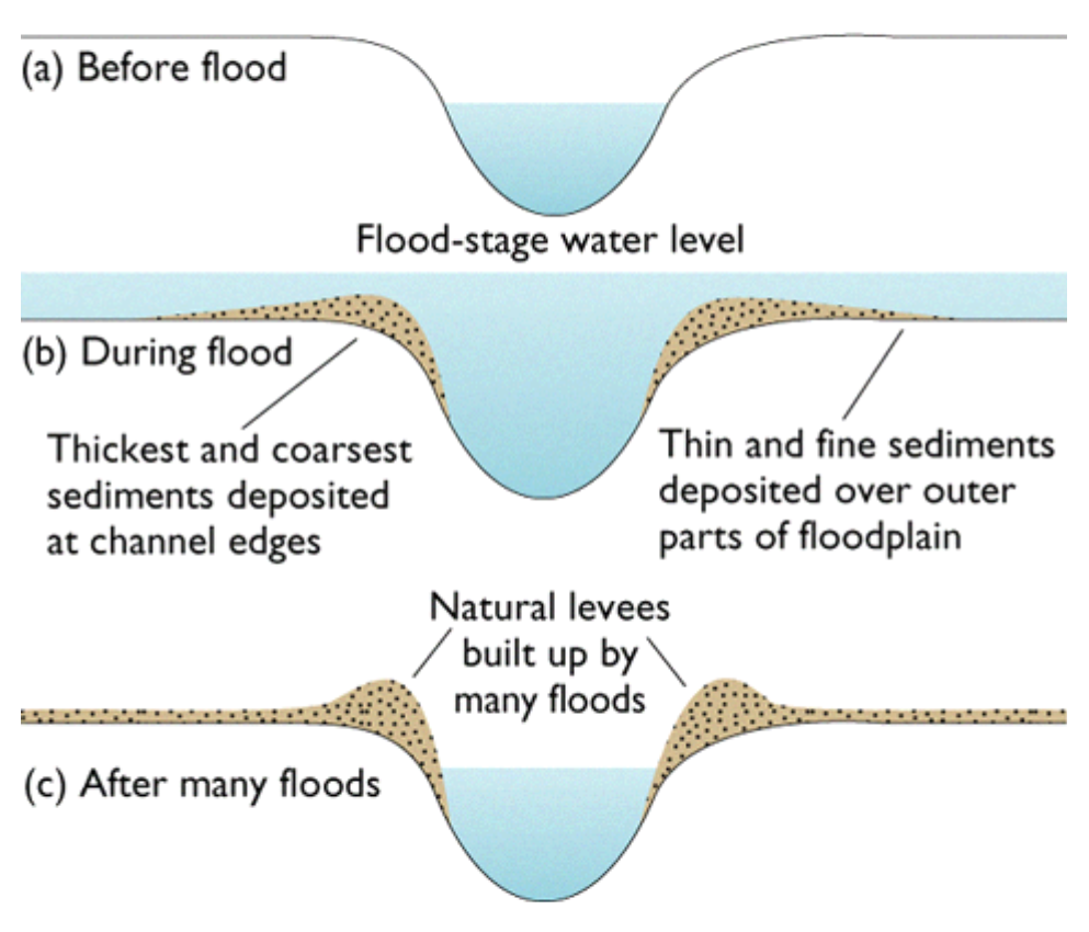
The flow of the river carves out the channel, and the main body of water often stays in that channel. However, during flood stages, the river may swell up and overtop its natural banks and water will spread out along the floodplain. Hence why it's called a floodplain - it's literally the flat(ish) areas where flood waters spread out. During flood stage, waters spread out and slow down, and drop sediment. Coarser sediments that were suspended in the water column drop out first because they are heavier. So sands drop out first, and clays last. So then you end up with a natural levee along the river bank.
Since we're talking about the Mississippi, here's an example of that:
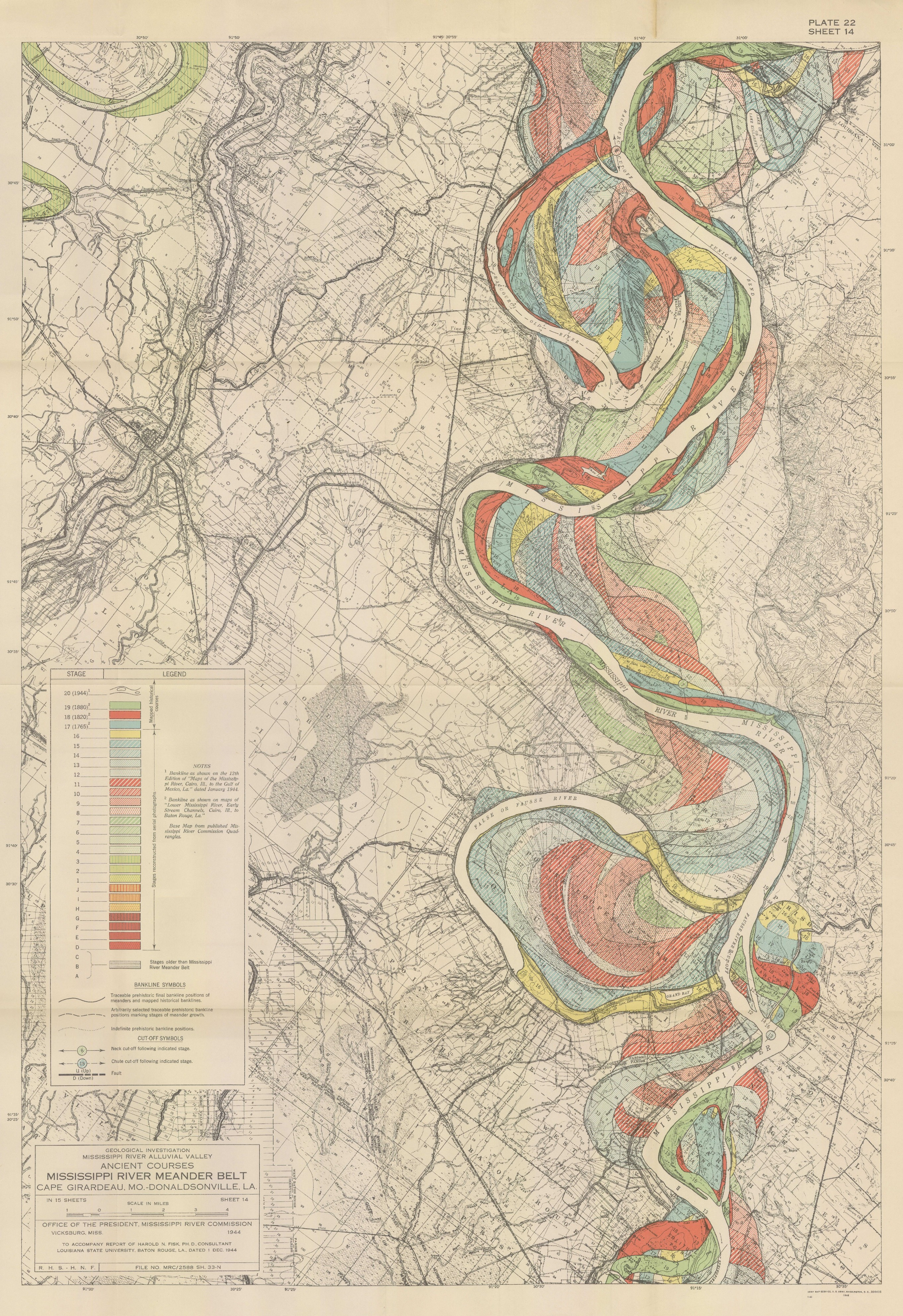
There is no "original" channel of the Mississippi River. Not really. It has meandered all over the place for most of its length. But, in Baton Rouge, it's moved east and west of its current location. In one of those more easterly renditions, it created a natural levee that is still visible today. And most people probably have no idea. Highland Road, which runs through the LSU campus, is a natural ridge. It is an old natural levee of the Mississippi River. If you live around here, next time you drive across Highland Road from east to west, and notice how the land drops off on the western side as you head towards the river. These days, the river is contained in levees a mile or more away from there, so no longer uses that natural feature.

Within the water column in the river channel, rivers can carry many different things - physical debris, sediment, nutrients, flood water, pollutants, and fresh water or salt water. These can all have different effects at different parts of the system.
So rivers carry sediment in some capacity, and in that vein they can cause erosion and deposition along the channel. That's why river channels move over time, or sandbars shift back and forth, and why shallow rivers used for navigation need to be dredged. The sediment is ever moving.
I literally cannot have said it more clearly myself, so here is how deltaic wetlands are formed:
"Deltaic formation begins as sediment laden river water reaches the ocean and slows down causing much of the sediment to drop out of suspension. Over time this accumulation of sediment leads to the formation of bars and shoals that further divert the water, causing increased deposition. Flooding causes increased sediment loss, leading to the formation bars and shoals extending above sea level. This newly-formed land is colonized with vegetation, which leads to further deposition and speeds up the land-growing process. Floating mats of vegetation form causing the water flow to slow and drainage becomes sluggish. The large amounts of vegetation and low flow cause anaerobic conditions to form." [source: Wetland Formation]
The flow of the river carves out the channel, and the main body of water often stays in that channel. However, during flood stages, the river may swell up and overtop its natural banks and water will spread out along the floodplain. Hence why it's called a floodplain - it's literally the flat(ish) areas where flood waters spread out. During flood stage, waters spread out and slow down, and drop sediment. Coarser sediments that were suspended in the water column drop out first because they are heavier. So sands drop out first, and clays last. So then you end up with a natural levee along the river bank.
Source: Should I trust that levee?
Since we're talking about the Mississippi, here's an example of that:
There is no "original" channel of the Mississippi River. Not really. It has meandered all over the place for most of its length. But, in Baton Rouge, it's moved east and west of its current location. In one of those more easterly renditions, it created a natural levee that is still visible today. And most people probably have no idea. Highland Road, which runs through the LSU campus, is a natural ridge. It is an old natural levee of the Mississippi River. If you live around here, next time you drive across Highland Road from east to west, and notice how the land drops off on the western side as you head towards the river. These days, the river is contained in levees a mile or more away from there, so no longer uses that natural feature.
Within the water column in the river channel, rivers can carry many different things - physical debris, sediment, nutrients, flood water, pollutants, and fresh water or salt water. These can all have different effects at different parts of the system.
So rivers carry sediment in some capacity, and in that vein they can cause erosion and deposition along the channel. That's why river channels move over time, or sandbars shift back and forth, and why shallow rivers used for navigation need to be dredged. The sediment is ever moving.
I literally cannot have said it more clearly myself, so here is how deltaic wetlands are formed:
"Deltaic formation begins as sediment laden river water reaches the ocean and slows down causing much of the sediment to drop out of suspension. Over time this accumulation of sediment leads to the formation of bars and shoals that further divert the water, causing increased deposition. Flooding causes increased sediment loss, leading to the formation bars and shoals extending above sea level. This newly-formed land is colonized with vegetation, which leads to further deposition and speeds up the land-growing process. Floating mats of vegetation form causing the water flow to slow and drainage becomes sluggish. The large amounts of vegetation and low flow cause anaerobic conditions to form." [source: Wetland Formation]
Over time, these wetlands are self fulfilling. Wetlands capture sediment, and in turn build more wetlands. It's a beautiful system. This process is how southeastern Louisiana's wetlands were formed. As the Mississippi River swung back and forth over thousands of years (also known as avulsion), this process repeated over and over across many former deltas. What's left today is a vast system of coastal wetlands [which has it's own set of problems, to be discussed in a future part].
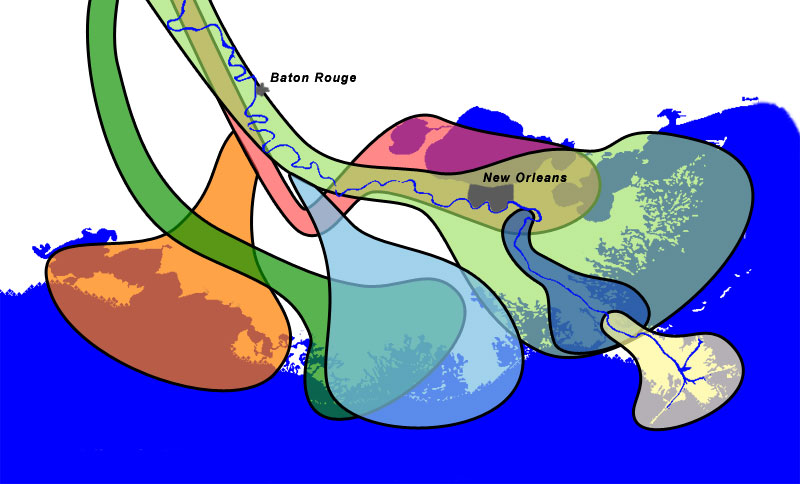
The river has been pretty settled in the current channel for a few thousand years now, and would love to switch course (if rivers had emotions). However, we have pretty effectively captured the Mississippi and forced it to stay on its course to our own liking. I'll discuss this more in depth in Part 4.
Stay tuned for Part 3, where I discuss all the values (economic, recreational, societal, environmental, and otherwise) of these coastal wetlands that were created by the Mighty Mississippi!
Note:
Stay tuned for Part 3, where I discuss all the values (economic, recreational, societal, environmental, and otherwise) of these coastal wetlands that were created by the Mighty Mississippi!
Note:
For the purposes of this series, the lower Mississippi and how it has formed the coastal wetlands of Louisiana are the main focus. The channel has shifted over time above Baton Rouge and plenty between there and Cape Girardeau (see the Fisk maps from 1944). I also acknowledge that different sections of the river have different challenges and benefits.
River National Geographic, accessed 1/1/2019
Should I trust that levee? Missouri S&T University, accessed 1/9/2019
Harold Fisk 1944 Maps Radial Cartography, accessed 1/9/2019
Wetland Formation accessed 1/9/2019
Mississippi Delta Lobes Wikimedia, accessed 1/9/2019
Mississippi River Delta Wikipedia, accessed 1/9/2019
How the Delta formed Restore, accessed 1/9/2019
